
A detailed guide documenting my self-guided Maria Island Walk in Tasmania. Follow my 3-day hike on Maria Island circuit route. Experience sweeping bays, epic island views on Mount Maria, world heritage convict history and abundant wildlife.
Maria Island is widely known as one of Australia’s best island sanctuaries. Many visitors make the trip every year to see the incredible wildlife diversity, to learn about Tasmania’s convict history and to hike its rugged peaks.
By far, the best way to experience it all is to complete a Maria Island walk on a loop from Darlington to the isthmus. In this guide, I’ll detail my experience hiking the Maria Island circuit on my own self-guided route. My goal is to provide you with the most useful information and the most inspiring photography from my journey to convince you to tackle it yourself!


About the Maria Island Walk
- Hiking Distance: 50 km (including a side trip to the Isthmus, Bishop & Clerk pinnacles & Mount Maria summit)
- Duration: 3 Days
- Elevation: 1935 m total elevation gain
- Difficulty: Moderate but long, entry-level mutli-day hike
Maria Island is a hiking and bushwalking paradise. Since there are no cars on the island, the only means of getting around are walking or renting a pushbike. This makes Maria Island a perfect multi-day hiking destination with plenty to see in between.
I've broken this Maria Island Walk into three days in order to get the most out of the experience. All tracks are accessible and well-formed and can be completed by almost anyone with a decent level of fitness and a bit of determination.
The only real elevation on this circuit hike are two steep climbs on the Bishop and Clerk track and to the summit of Mount Maria. Technically, these are both side trips but I highly recommend checking them out as they were clear stand-outs for me.

Highlights of the Walk:
- Incredible wildlife spotting opportunities
- Summiting the Bishop and Clerk Pinnacles
- Seeing the Fossil Cliffs
- Camping in the old convict village in Darlington
- Stopping by the Painted Cliffs
- Walking to the Isthmus and Point Lesueur
- Camping at Frenchs Farm
- Summiting Mount Maria
Since this is a self-guided and self-sustained 3-day walking route, you will need to pack all of your food and sleeping gear for the trip. If you'd prefer to explore Maria Island on a pack-free walk, then I'd recommend checking out this active full-day walking tour of Maria Island which you can book online with GetYourGuide.

Where to Stay Near Triabunna Before & After The Hike
Triabunna is the main town that you will need to head to before and after your hike on Maria Island. Below I've included some of the best places to stay near Triabunna to help you better plan your walk on the Maria Island circuit.
- Closest to Triabunna Ferry: Triabunna Cabin and Caravan Park
This is the only place available to stay in the actual township of Triabunna. This caravan park offers campsites and cabins within walking distance of the ferry and close to shops. - Best nearby hotel: Eastcoaster Tasmania - Right around the corner from Triabunna is this really well-rated studio hotel in Orford. It has two swimming pools, a private beach, a hot tub, a tennis court and a basketball court. There's also a really good restaurant and bar which is great after three days hiking the Maria Island Circuit!
Maria Island Walk GPX File and Map
Below is a GPX track formulated using my Garmin GPS watch. I've also created a map below which outlines the two campsites on this circuit as well as the two peaks with elevation data.
You can also head over to my Strava for more detailed information on the route.
GPX File: Download

Related: 2-Day Freycinet Peninsula Circuit

#1 Water Bottle Filter
Enter the Grayl GeoPress Water Filter & Purifier Bottle! I take this bottle on every hike and use it as my go-to source for filtering water all over the world. I've even used it to drink tap water in India!
// Compare how the GeoPress stacks up against the best water bottle filters on the market.
Things to Know About the Maria Island Walk
Before we get into the detailed guide and photos, below are some quick tips about walking on Maria Island (pronounced Mah-reye-ah, not Mah-ree-ah).
If you're looking for more things to do on Maria Island as well as more important visitor information, then make sure to check out my full Maria Island travel guide.
Booking the Maria Island Ferry
Since Maria Island doesn't share a landbridge with Tasmania, you will need to book a ferry. This is a passenger-only ferry and there are no cars on the island. However, you can bring your bike if you'd prefer to ride around to some of the highlights on Maria.
Update 2023: There is now a very convenient and affordable shuttle bus service operating round trips from Hobart to Triabunna for under $40.
The boat departs a few times a day depending on the season and only takes roughly 30 minutes. You can only book return tickets and it's best to book on their website in advance.
If you're doing the 3-day Maria Island walk like me, you'll need to pay an additional baggage fee, since you only get a small 7-kilogram carry-on bag included in the ticket.

Car Rentals in Tasmania
Unfortunately, the cost of bringing your own car on the Spirit of Tasmania has skyrocketed in recent years.
Now, it is usually cheaper to rent a car on arrival. I recommend using RentalCars.com in Tasmania to compare rates for different vehicles across dealerships.
(Rentals are limited in Tasmania so it's a good idea to book in advance).
Camping on the Maria Island Walk
There are three campsites on Maria Island. These are:
- Darlington Campsite
- French's Farm
- Encampment Cove
Darlington campsite costs $7 for one, or $13 for two people in a tent. This is actually great value as there are free cold showers (hot shower is $2-coin), toilets, an undercover kitchen area with a BBQ and fireplace (free firewood), lockers and filtered drinking water.

I recommend staying here on your first night so that you can walk the top loop (including Bishop and Clerk) and leave your heavy items in your tent.
On the second night of this Maria Island circuit walk, I stayed at French's Farm. This has fewer facilities and only offers tank water. However, there is a toilet here as well as an old cabin. There's also an option to stay at nearby Encampment Cove. But, I can't vouch much for it as I didn't stay here. Both of these campsites are free.

Other Quick Things to Know
- There are no bins on Maria Island, you need to practice the "leave no trace" principle and pack out all of your rubbish
- TasParks recommends keeping at least 2-metres away from all wildlife
- You will need a Tasmanian National Parks Pass, I recommend the yearly one for the best value
- There's a large carpark at Triabunna ferry terminal where you can leave your car for free (has security cameras). Alternatively, ask your accommodation in Triabunna
- Fires are only permitted in Darlington camp kitchen, therefore you need to pack a good hiking stove for cooking
- Filtered water is only available at Darlington but there is tank water at French's Farm which they recommend you filter. I use a Grayl Purifier bottle to filter water everywhere I go.
- There are toilets at Darlington and French's Farm campsites

How I Stay Connected Off-Grid
I've been using the Garmin InReach Mini satellite communicator for all serious treks and expeditions since 2020. It lets me send unlimited SMS anywhere on earth and has an emergency SOS feature that could save your life.
The Maria Island Walk: Self-Guided Circuit Route
With all of that information out of the way, let's get into the route for the Maria Island walk (self-guided). In this section, I'll document my experience hiking the circuit and provide photos that I captured along the way.
Day 1: The Northern Loop
We chose to get the 2:30 PM ferry to Darlington since we had just arrived in Triabunna earlier that morning after hiking in Freycinet National Park for two days. This was fine as we planned to quickly pitch our tent and walk the northern loop of Maria and summit the Bishop and Clerk pinnacles for sunset.
Upon arriving in Darlington, we quickly dropped our bags at the campsite before heading towards the Bishop and Clerk track.


We walked this loop in an anti-clockwise direction, starting from Darlington and passing the Twelve Apostles, the ruins of twelve brick buildings from 1880 constructed to house workers in the wine industry.
Then, we continued on up the Brickfields Valley towards a fork at the edge of a towering bluff. This section is wide and clear, with gently rolling hills dramatically giving way to sheer cliff drops.

The Bishop and Clerk Track
Once at the bluff, the towering pillars of the Bishop and Clerk Pinnacles are already visible at the far end of the coast. This section was one of the highlights of the Maria Island walk for me. It's the second steepest section of the hike after Mount Maria and offers arguably the best views.
It begins by following the dramatic grassy coastline before entering a dense forest. Soon, the track opens up to a large boulder field which slowly turns to sharp scrambling near the top.

The views from the Bishop and Clerk summit are really something else. These dolerite pinnacles are over 600 metres tall and fall vertically to the ocean below.
Read more details and see more photos from the Bishop and Clerk track.


The Ultimate Tasmania Travel Resource
Looking for more Tasmania travel guides & adventure inspiration? Below are my most comprehensive blog posts that will serve as a great free resource for your trip.
Back to Darlington Campground via Fossil Cliffs
At the summit, the legs were definitely warmed up and ready for the next couple of days walking around Maria Island. After taking in the view, I headed down on the same route back to the fork near the Fossil Cliffs.
These cliffs extend on the northern shore of Maria Island and were once the site of a limestone quarry. The mining has revealed million-year-old fossils lodged in the cliff that document the natural history of the island.

The sun was well and truly setting now on the northern loop back to Darlington. This meant that animals were out and about, enjoying their evening graze.

This loop returns back to Darlington campsite via the landing strip and the old cement works. All-in-all it took me roughly 3 hours of moving time (13.5KM) to complete this top loop, including summiting the pinnacles. However, plan for at least 4-5 hours to enjoy the views on the way.

We wrapped up this first day hiking the Maria Island circuit by enjoying a meal at the campsite kitchen beside the fireplace. We took advantage of the free lockers and left some of our heavier food and some clean clothes to enjoy once we returned.
Day 2: Frenchs Farm Costal Route
The first day on this self-guided Maria Island walk is pretty much as far as most visitors to the island get. It encompasses many of the primary highlights you'll see and hear about. But it's a real shame because Maria Island has so much more to offer!
Day two is an easy walk departing Darlington Campground towards French's Farm along the coast. There isn't any elevation to gain so it's mostly just a scenic stroll with plenty of wildlife spotting.

Darlington to Painted Cliffs
Just 2 kilometres from Darlington is stop worthy of laying down the packs and exploring. Known as the Painted cliffs, these beautifully coloured and patterned sandstone walls are truly a sight to behold.
It's best to visit these cliffs within two hours of low tide as the water level can get quite high. However, we were still able to climb around the cliff and descend on a worn track down to the sandstone walls during high tide.


Soldier's Beach & Four Mile Creek
Continuing on from the Painted Cliffs, the track reenters the forest on a wide, cleared track. If you keep quiet and a watchful eye out, there are great opportunities for bird and wildlife spotting.
Along the way to French's Farm, we passed Four Mile Beach and creek. I'm assuming that the name stems from the length of the creek and not the beach because the beach is probably less than 100 metres long.
This would be a good place to rest and have some lunch but we decided to carry on to Frenchs Farm to set up our camp and explore the area. From Darlington, the walk to the campsite is just over 10 kilometres and took us around 3 hours at a leisurely pace with heavy packs.

Camping at French's Farm
The French's Farm campsite is a beautiful spot in a large clearing. It used to be a private residence for the French family, who I presume donated it for National Parks initiatives.

The French's Farm campsite is very spacious, with plenty of flat spots to pitch a tent. There is also the old French's barn and shearing shed here to explore. I was told not to leave any food in the shearing shed overnight as there are rats.
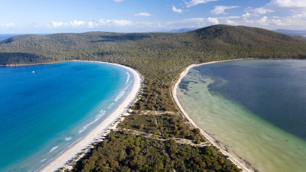
We spend the afternoon exploring the area and walking to Mcrae's Isthmus, a long, narrow neck of sand connecting the two ends of the island. Once back at French's Farm campground, we enjoyed the golden lighting provided by the westering sun and snapped photos of wallabies, potoroos, wombats and birds.

Optional Side Trips on Day 2 of the Maria Island Walk
Near the fork leading to French's Farm campground, there is another path leading to Encampment Cove. Unfortunately, we ran out of light to explore this region. However, if you have time, I'm sure it will be worth it.
It's possible to walk all the way to Point Lesueur, where you will find the ruins of an old probation station and convict cells.

Day 3: The Inland Route & Mount Maria Summit
The final day walking the Maria Island circuit loops back to Darlington via the inland track. There's also an option to summit Mount Maria on the way, which I highly recommend doing.
Frenchs Farm to Mount Maria Trailhead
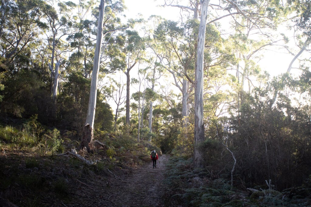
We packed up our tent before first light in hopes of getting to the Mount Maria summit before the forecasted rain. The track begins by doubling back on the same route and then splits at a wide, signed fork.
The inland track towards Mount Maria is narrower and more rooty than the coastal track. It also undulates more but it really isn't anything too difficult. Being further in the interior of the island, this section is also teaming with wildlife and the plant diversity is greater.
Approximately 8KM after leaving French's Farm, we were at the fork. I left my heavy pack behind a tree and pushed on towards the summit.

Mount Maria Summit Track
The Mount Maria track is much narrower than any other section on the Maria Island walk so far. It's also the steepest section with the most elevation to gain. My watch said that we were at around 90 metres above sea level at the fork. This track then climbed continuously over 6.2 kilometres to an altitude of 720M AMSL at the summit of Mount Maria.
It was interesting to see how the plants and trees changed from dry eucalypts to an almost temperate rainforest with wet ferns and hanging moss as I ascended Mount Maria.

There were yellow and orange reflective arrows that marked the route all the way to the summit. Similarly to the Bishop and Clerk track, the forested section quickly opened up to a wide boulder field as I approached the summit.


Apparently, these dolerite boulders and scree fields are the result of cracking erosion during the last glaciation approximately 20 000 years ago. Keep an eye out for cairns and arrows, which mark the best way to traverse these large boulders.

Approaching the summit, it was once again necessary to climb and scramble a near-vertical wall of boulders. Don't worry too much, climbing isn't at all difficult, but you will need to perform a fairly steep scramble over the rocks. It took me approximately 1 hour and 20 minutes to reach the summit from the trailhead at a fairly good pace.

Mount Maria Summit
Due to its height, Mount Maris is often covered with clouds. I was fortunate on my ascent to have a clear view, apart from a few sunshowers and devastating wind.
From the top, I had unhindered views of the entire Island, the isthmus, Darlington and even Freycinet National Park far away in the distance. The true summit is just a pile of boulders with a trig station at the highest point. I honestly thought this thing was going to be blown down the mountain in the wind but it stayed true.


The Descent
Turning back, the descent back to the inland track is just doubling back on the same route. I was expecting this to be a tough decline on the knees but it really wasn't too bad at all. The elevation is spaced out over 6 kilometres, making the walk down very tolerable.
Once I got back to the fork, I re-packed my bag and continued on the rest of the inland track toward Darlington.

The Oast House Track
Just 2.5 kilometres from the fork, the track gives way to the option of looping back to Darlington via the Oast House Track. The distance here is roughly the same, so I decided to follow this route so as not to repeat the first section.
The Oast house is another ruin from another industrial venture on Maria Island. This time, it was beer and hops that was processed here. There isn't much left of the building, but it was interesting to check it out and read about the history on the information plaques.

Return to Darlington
From the Oast House, it was a short, gentle walk back to Darlington campground. We finished off this incredible self-guided Maria Island walk by resting our tired legs by the fire at the campground kitchen.
Our ferry was booked for 4:15 PM that afternoon. However, since the weather was worsening, we decided to jump on the 2:30 PM ferry back to Triabunna instead.


What to Bring on the Hike: Packing List
Here are some things that you definitely want to bing on this self-guided Maria Island walk.
- A good hiking backpack
- Lightweight food for the duration of the hike (freeze-dried meals, noodles, mac & cheese, nuts, trail mix, dried fruits etc)
- Plenty of water
- Warm sleeping bag
- Sleeping clothes
- Hiking boots or trail shoes
- Socks
- Head torch
- Swimmers
- Toiletries/medication
- Hardshell rain jacket
- UL tent
- Sleeping pad
- UL cookware, gas stove, gas
- Phone (4G available along the coast on both sides)
- National Parks Pass
- Camera
Discover More Tasmanian Hiking & Adventure Guides
And that's a wrap for this guide to hiking the Maria Island walk self-guided. If you enjoyed the Maria Island Circuit, why not check out some of my other adventure and travel guides for Tasmania?