
Everything you need to know about the Cape Raoul hike in Tasmania. How to complete the Cape Raoul Walk to the lookout independently. Also includes an optional side trip to the lookout on the Shipstern Bluff Walk
Cape Raoul is the third cape on Tasmania’s famous Three Capes Track. However, this particular cape isn’t accessible on the island’s famed multi-day walk and you will need to drive to the bottom of the Tasman Peninsula to hike to the Cape Raoul lookout.
In this blog post, I aim to share with you everything you need to know about hiking to Cape Raoul on the Tasman Peninsula. I’ve also included an optional side trip on the Shipstern Bluff walk, which overlooks one of the world’s most massive wave breaks.
Where is Cape Raoul
Cape Raoul is the southernmost cape on Tasmania's untamed Tasman Peninsula. The cape is accessible via a hike from the newly-established Cape Raoul Trailhead Carpark, approximately 112 kilometres from Hobart, or just 18 kilometres (20 minutes) from Port Arthur.
Below I have pinned the exact location of the carpark which is updated and accurate. However, getting here by relying solely on Google's navigation may or may not be the best idea. I've provided detailed instructions on how to reach the trailhead below.
- GPS Coordinates: "Cape Raoul Trailhead Carpark"
Unfortunately, if you don't have your own transport, you're out of luck. There aren't any tours or public transport options for this one. If you're set on seeing the Tasman Peninsula, you can instead book a walking tour to Cape Hauy instead.

DON'T MISS NEARBY: Guide to Visiting the Remarkable Cave

Car Rentals in Tasmania
Unfortunately, the cost of bringing your own car on the Spirit of Tasmania has skyrocketed in recent years.
Now, it is usually cheaper to rent a car on arrival. I recommend using RentalCars.com in Tasmania to compare rates for different vehicles across dealerships.
(Rentals are limited in Tasmania so it's a good idea to book in advance).
How to Get to the Cape Raoul Trailhead
The best directions for how to get to the Cape Raoul walking track is to head towards Port Arthur on Arthur Highway. Next, you'll want to continue past the Historic Site turnoff and follow the highway (it becomes Nubeena Road).
Follow Nubeena road until you see a left turn onto Stormlea Road. Follow this road all the way to the end and don't take any forks. The road is sealed except for the last kilometre or so. However, don't worry too much, we managed without any issues in our big campervan.
The trailhead carpark for the Cape Raoul walk is at the end of the road. Here, you'll find a huge car park, toilets and information boards about the hikes.
How to pronounce Raoul: Rah-ool

The Cape Raoul Hike
- Hiking Distance: 16.4 km return (18 km including a short side-trip to the Shipstern Bluff Walk)
- Duration: 3.5 - 5 hours return
- Elevation: 645 m total elevation gain (undulates)
- Difficulty: Moderate
The Cape Raoul hike is a fairly long walk that begins by gently climbing up eucalypt forest and then descending down to the long plateau reaching out to Cape Raoul. It's not a difficult hike in terms of physical ability or navigation, but always remember that conditions can change quickly in Tasmania.
We completed the Cape Raoul walk to the edge of the Cape in roughly 3.5 hours moving at a fairly brisk pace. This included a short 1.6 kilometre return detour to the lookout over Shipstern Bluff, one of the world's biggest surf breaks. However, you can expect to take up to 5-6 hours to complete this walk as is listed on the Tasmania Parks website.
There are also ways to shorten the hike by turning around at the Cape Raoul lookout, which is a good spot to view the cape atop the high point on the coastal bluff. This would make it a quick and easy 4.4 kilometre return walk.
However, let me convince you that the views from Cape Raoul are much better and definitely worth the effort! Below is a detailed account of my experience on the Cape Raoul hike in Tasmania.

The Ultimate Tasmania Travel Resource
Looking for more Tasmania travel guides & adventure inspiration? Below are my most comprehensive blog posts that will serve as a great free resource for your trip.
First Section: Gentle Climb Through Open Forest
The walk begins by gently climbing through dry, open eucalypt forest. The track is well-maintained here and throughout, reflecting the popularity of the walk.


After approximately 1.7 kilometres, the track forks with signs showing left for Cape Raoul and right for Shipstern Bluff. We decided to take the short 1.6 kilometre (return) detour to check out the Shipstern Bluff lookout. This track is much more of the same, but descends a little down to the lookout point on the Shipstern Bluff walk.
Optional Side Trip on the Shipstern Bluff Walk
Shipstern Bluff is the proving ground of the world's largest big-wave surf competitions. Known as Cape Fear, this comp brings together some of the world's best big-wave surfers to Tasmania's southern shores every year. Unfortunately, there is no set date for the comp as it largely depends on the swell. As a result, the competition at Shipstern Bluff is usually called spontaneously.
If you're lucky enough to be sharing the Shipstern Bluff walk with some of the world's best surfers, then screw Cape Raoul! Unfortunately for us, we made it to the Shipstern Bluff lookout on a day with very little swell. Still, it was a good little side trip and the coastal views are certainly worth the extra steps.


After admiring the view, we turned back and began the ascent back on the Cape Raoul hike.
Cape Raoul Lookout
After approximately 2.2 kilometres (3.6 KM for us), you'll reach the Cape Raoul lookout. This is a popular spot for many people who aren't keen on a big hike and would rather just call it early.
The views are quite impressive, with sheer cliff drops and deep blue water of the Tasman Sea below. However, the Cape Raoul lookout doesn't really compare with the actual cape view, so we pushed on.

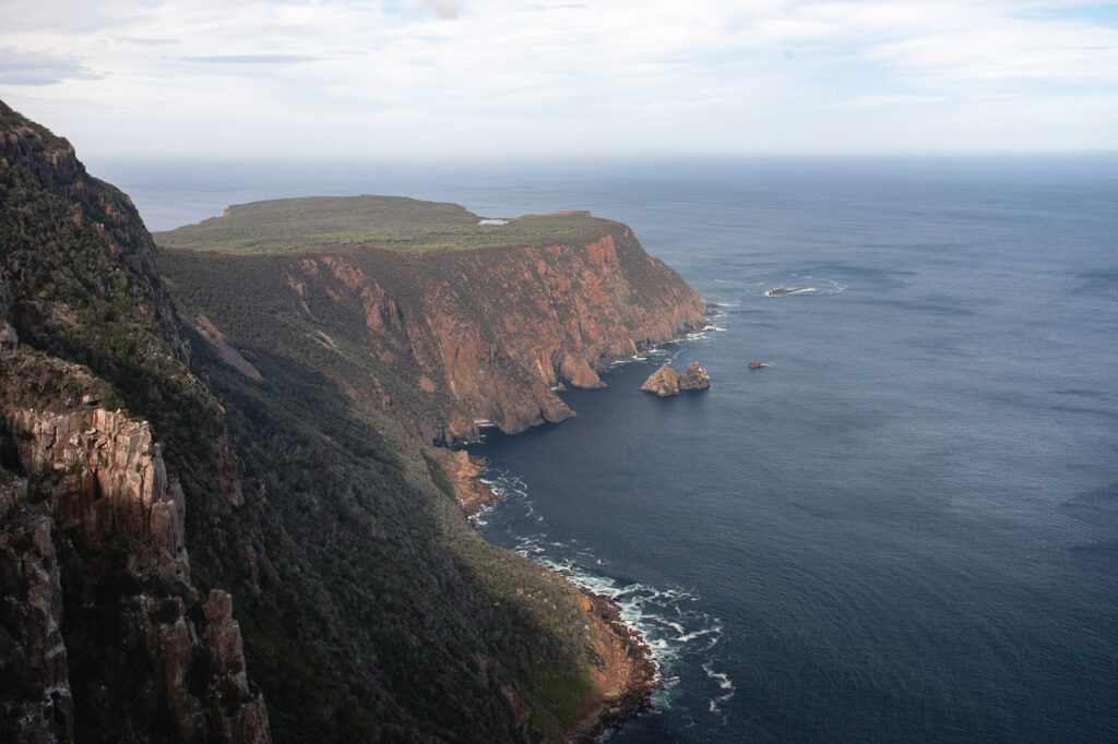
The Descent to The Cape
After making it to the top of the bluff, the terrain changed to a more temperate rainforest feel. While not offering much in terms of views, this was one of the most scenic parts of the trail, with large trees and dense ferns dominating the sides of the track.

Then, as we gained the high ground, the track began to decline on a windy path to the flat plateau stretching out to Cape Raoul. This section is quite easy on the decline and not too steep. But, be prepared that you'll need to face this section on the way back up too.
Along the descent, there are plenty of epic coastal views in pockets of forest opening. These offered a great excuse to take a short rest and snap some photos.


Cape Raoul Lookout
After making it down to level ground, we still had a 2.8 kilometre flat walk to reach the cape. There aren't many spots to admire the view along this section, so we pushed on.
Just before the Cape Raoul Viewpoint over Raoul Rock, there is a large tarn. Beside this, there are some epic coastal cliff formations worthy of some photos. Also, you'll find wooden boardwalks on this section that has been built to protect the track. The entire flat section leading out to the cape is mostly just low lying bush and coastal heathland, a stark contrast to the wet forests less than an hour earlier.


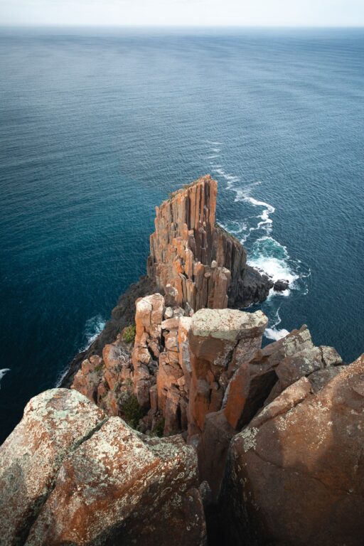
The Cape Raoul Viewpoint looks directly out to the Tasman Sea. It's a set of several large pillared rock formations that seem to be stretching out as far as they can. To your we, saw Cape Pillar and the famous Blade, which we climbed two days prior on the Three Capes Track.

#1 Water Bottle Filter
Enter the Grayl GeoPress Water Filter & Purifier Bottle! I take this bottle on every hike and use it as my go-to source for filtering water all over the world. I've even used it to drink tap water in India!
// Compare how the GeoPress stacks up against the best water bottle filters on the market.
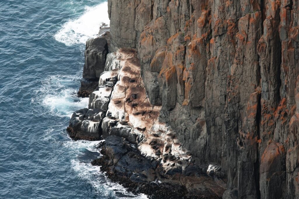
Seal Rock Lookout
Just around the bend from the main cape viewpoint you will find Seal Rock lookout. This offers excellent views of the actual cape and you can often spot some seals basking and hunting on the rocks below.


Once we'd etched the view in our mind and taken a few photos, we turned back on the same track back towards the car park.

Shoul I Hike Cape Raoul or Cape Hauy?
If you're tossing up which of the Tasmanian Three Capes you'd like to check out on a day hike, let me help you out.
The Cape Raoul hike is a much longer walk but offers a very similar view. In my opinion, Cape Hauy is equally as impressive if not more so. The option of which track to take ultimately comes down to how long you'd like to hike.
If that didn't help your dilemma, then let me complicate it further by saying that Cape Pillar is by far the most impressive! However, this is a much longer walk and typically takes at least two days. However, it is possible to walk to Cape Pillar on a rather long day walk, or alternatively spend the night at the free in-between camp spot (more information on my full guide to the Three Capes).


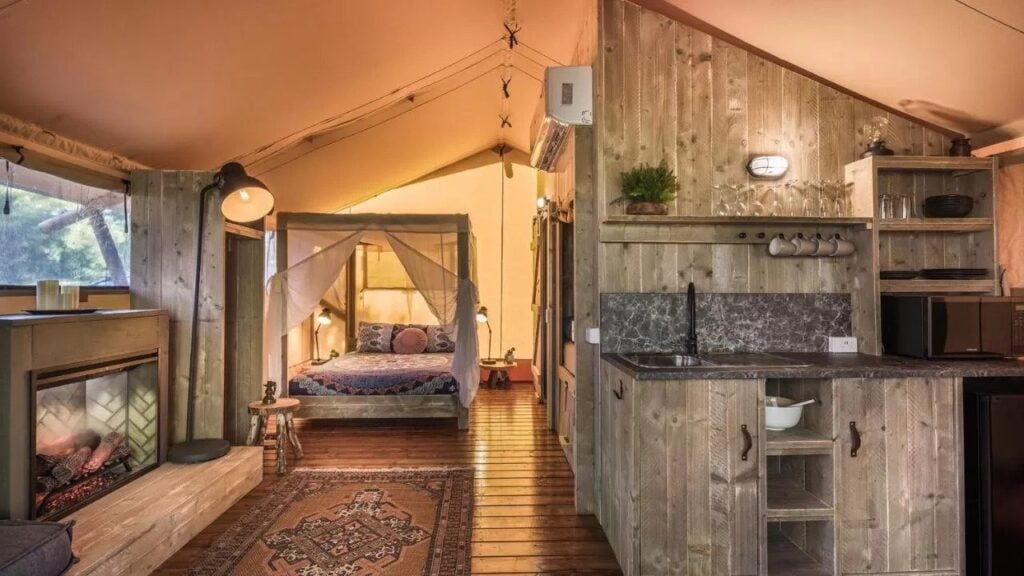
Accommodation Near Cape Raoul Tasmania
Looking for a place to stay on the Tasman Peninsula close to Port Arthur and all of the hiking trails? Don't worry, I've got you covered. Below is a great list for Cape Raoul accommodation options close to the trail.
- Stewarts Bay Lodge - The Stewarts Bay Lodge is a beautiful private lodge located on 22 acres of private land just beside the Port Arthur Historic Site. Chalets with a spa bath, large sunny deck and water views are also available.
- Private, self-contained villa: Port Arthur Resort - Conveniently located near Port Arthur, the Port Arthur Resort offers self-contained private villas with guest laundry for your smelly hiking clothes, BBQ facilities, a fully-equipped kitchen, dishwasher and minibar.
- Budget option: NRMA Port Arthur Holiday Park - If you'd like to get into a warm, private cabin accommodation on a budget, then make sure to check out the Port Arthur Holiday Park. The park is within 16 minutes drive of many attractions including Eaglehawk Neck and the Remarkable Cave.
More Tasmanian Adventure Articles and Travel Inspiration
Did you find this hiking guide to the Cape Raoul track in Tasmania useful? If so, I've written dozens of adventure guides to Tassie that I'm sure you'll also love. Below are a few of my favourites in the region.
Julia Patten
Saturday 13th of November 2021
What a great guide! Thank you - I"m planning a trip for my family and this is extremely helpful.
Olly Gaspar
Sunday 14th of November 2021
You're welcome Julia, enjoy the hike!