
Waterfall and hiking guide to Halls Falls Tasmania. Enjoy an easy, yet scenic hike to this multi-tiered waterfall on the Groom River.
Halls Falls is a set of multiple cascading waterfalls located on the Groom River near Pyengana. This short waterfall circuit features several viewing points of the cascades, as well as a rock-pool area and a historic, 19th-century weir.
We visited this waterfall after some heavy rainfall. As a result, the photos on this blog show it in full force and they may or may not be flowing as hard when you visit.


Where is Halls Falls?
As mentioned, the walking track to Halls Falls is located near the village of Pyengana in the Tasmanian northeast. This is approximately 22 kilometres from St Helens or just over 145 kilometres from Launceston.
How to Get to Halls Falls
To get to the Halls Falls Trailhead, you'll need to make your way towards Pyengana on the Tasman Highway (A3). You will find the waterfall car park roughly 1.2 km down a dirt road known as Anchor Road. This road is on the corner of a small bend and can be easily missed. However, there are signs indicating the way to the falls.
The dirt road (Anchor Road) is a little rough but it's only a short way to the trailhead car park. Our big van made it there without any trouble.

Car Rentals in Tasmania
Unfortunately, the cost of bringing your own car on the Spirit of Tasmania has skyrocketed in recent years.
Now, it is usually cheaper to rent a car on arrival. I recommend using RentalCars.com in Tasmania to compare rates for different vehicles across dealerships.
(Rentals are limited in Tasmania so it's a good idea to book in advance).
The Halls Falls Circuit
- Hiking Distance: 2.5 km return
- Duration: 1 - 1.5 hours
- Difficulty: Easy
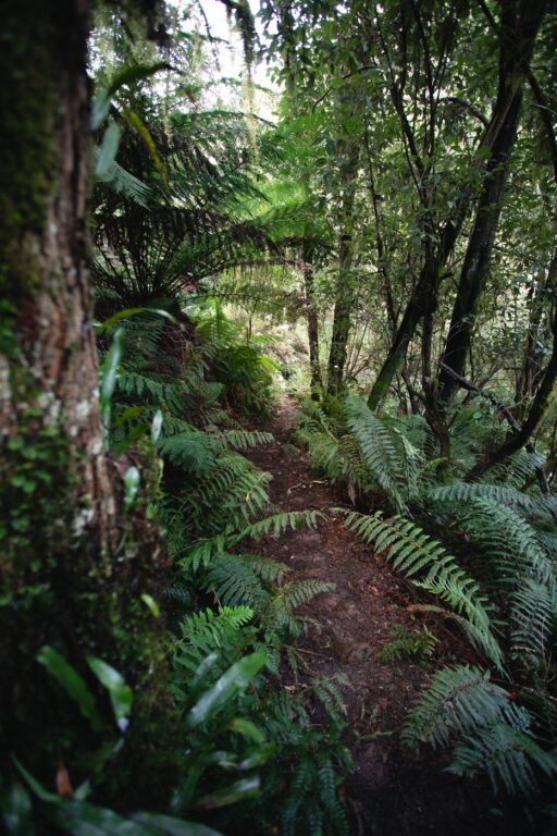
The Halls Falls circuit is a relatively short and easy walk on a wide, well-graded dirt track. The track is mostly an in-and-out trail but you will have the option of taking a loop back to the car park from about halfway to the falls.
The flora here is a little drier than what you might find at the nearby St Columba Falls. There is a good mix of Aussie eucalypts and temperate rainforest myrtle trees and tall man ferns along the length of the track.

Other than the main waterfall, there are a few highlights along the way that are worth checking out too.
Halls Falls Map
Below I've included a basic map showing the route and distances to each attraction on the Halls Falls circuit.


The Ultimate Tasmania Travel Resource
Looking for more Tasmania travel guides & adventure inspiration? Below are my most comprehensive blog posts that will serve as a great free resource for your trip.
Halls Falls Tasmania - Waterfall Lookout
Less than one kilometre into the hike and you'll arrive at the main waterfall lookout. Truthfully, I found myself a little disappointed by this lookout. This was because it was a little tricky to see the scale of it due to the surrounding trees and shrubs.

Walking Down to the Base of the Bottom Tier
Thankfully, there is a relatively steep, yet short track down to the "rockpools" below. Here, you can admire the bottom-tier waterfall up-close.
This spot is labelled as "Rock Pools" on the Halls Falls map above. However, as you can see from the photos following heavy rain, there was no chance we were going to take a swim in these pools.


#1 Water Bottle Filter
Enter the Grayl GeoPress Water Filter & Purifier Bottle! I take this bottle on every hike and use it as my go-to source for filtering water all over the world. I've even used it to drink tap water in India!
// Compare how the GeoPress stacks up against the best water bottle filters on the market.
Top-Tier Falls
After snapping some shots of the bottom waterfall, we continued back up the track and onwards to the next waterfall at Halls Falls. This was really just a short, easy walk with only a little decline at the end to get to the waterfall.

The scale of the torrential rain that the area experienced was even more evident as soon as we made it here. We found trees and heavy logs smashed up against the banks of the Groom River just beyond the falls.

19th Century Weir at Halls Falls
The last attraction on the Halls Falls hike is the 19th Century weir. This man-made cascade and large, pooled area was used my 19th Century loggers to control the water level on the Groom River.
After stopping briefly, we found that there was another track that continued on beyond the weir, unmentioned on the Tasmania Parks map. We followed it for about a kilometre and ended up further upstream.
Here, the water flow was much calmer, and the orange banks were lined with beautiful, towering ferns. Whilst perhaps not an official attraction, I do recommend checking it out if you wish to continue on a little further.


More Adventures in Tasmania
Are you looking for more hikes, waterfalls and adventure attractions in Tasmania? Other than the Halls Falls hike, I've also written about several other epic locations in Tasmania! Make sure to check out some of my favourites below.
