
Hiking the Freycinet Peninsula Circuit is by far the best way to experience the incredible beauty of Tasmania’s Freycinet National Park. From white, sandy beaches to rocky mountain summits, this hiking guide covers everything you need to know about walking this epic multi-day hike, including climbing Mount Freycinet.
The Freycinet Peninsula Circuit is an epic circuit track around Freycinet National Park on the East Coast of Tasmania. Tasmanian Parks recommends this circuit as a good introduction to multi-day hiking in Tasmania as it is quite easy when compared to some of the other trails.
The circuit is great if you’re looking to see the most you can during your visit to the region. This is because it covers most of the famous trails including the Wineglass Bay lookout track, Hazards Beach track and a climb to the top of Mount Freycinet summit— the tallest peak in the park.
In this guide, I’ll outline everything you need to know about completing the Freycinet Peninsula Circuit, including tips for planning your trip and how to get the most out of the walk. At the bottom of this post, you’ll also find a short, but detailed section outlining important information such as campsites and water access on the track.
- Overview of the Freycinet Peninsula Circuit
- Planning the Freycinet Circuit: 2 Days or 3 Days?
- Freycinet Peninsula Circuit Map
- Freycinet Peninsula Circuit – Hiking Guide
- Getting to the Trailhead
- Wineglass Bay Lookout Track
- 1000 Steps Down to Wineglass Bay
- The Isthmus Track
- Hazard’s Beach to Cooks Beach
- Cooks Beach Campsite
- Cooks Beach to the Mount Freycinet Saddle
- Climbing Mount Freycinet
- Mount Graham
- The Quartzite Ridge to Wineglass Bay
- Wineglass Bay Beach
- Hazards Beach Circuit Back to the Carpark
- Finishing the Freycinet Peninsula Circuit Hike
- Resources: Things to Know Before You Hike the Freycinet Circuit
- Freycinet Peninsula Circuit Packing List
- Camping in Coles Bay
- More Adventures on Tasmania’s East Coast


Overview of the Freycinet Peninsula Circuit
- Hiking Distance: 46 km (walked in a "figure-eight" with Mount Freycinet summit & Bryans Beach track)
- Duration: 2 or 3 days
- Elevation: 1800 m total elevation gain
- Difficulty: Tasmanian Parks Grade 3 (entry-level multi-day trekking)
This post follows my experience hiking the Freycinet Peninsula Circuit in a "figure-eight" loop, with side trips to Mount Freycinet summit and Bryan's Beach from Cooks Beach. While this full circuit is a bit longer, I consider this the best way to walk it. That's because by doing it this way, you'll truly get to experience most of the best trails in Freycinet National Park on one big loop.
It's possible for hikers to walk this circuit in either two or three days. We decided to walk it in two, with a rather short first day and quite a long second day. All of the main campsites are on the beaches at either Cook's Beach, Hazard's Beach or the south end of Wineglass Bay.
We decided to spend the night at Cook's Beach campground. However, this meant that the second day was quite a stretch to summit both Mount Freycinet and Mount Graham before returning to the car park via the Hazards Beach track. So, instead, I'd recommend camping near the Mount Freycinet saddle to those taking a similar track over two days.
Overall, I'd consider the hike fairly easy for an overnight hike. Most of the trail is flat except for the elevation gain on the way up to Mount Freycinet and then again up the saddle to Mount Graham. In saying that, the long stretches of soft sand when walking on Hazard's Beach and Wineglass Bay can be a little draining on the calves.
The Freycinet Peninsula Circuit track is also very easy to follow and well-marked by orange, reflective arrows on trees and rocks. Also, being a popular walk means that the trail is wide and clear throughout all of the bush and forest sections.

Planning the Freycinet Circuit: 2 Days or 3 Days?
As mentioned, the Freycinet Peninsula Circuit can be completed in either two or three days of walking.
If you've got time, then three days would be a very leisurely walk with scenic camping spots at Cooks Beach and Wineglass Bay. Taking the three-day option would spread the walking out a lot and allow you to spend more time relaxing at the beach campsites.
However, I felt that two days of walking is the best way to do it. But as I mentioned, I would rather have broken up the days by camping at the saddle instead of staying at Cooks Beach on the first day.

Freycinet Peninsula Circuit Map
Below is a GPX map that I generated on my Garmin GPS watch. You can also download this GPX file by clicking the link below.
My Strava: View
Download: GPX File

Freycinet Peninsula Circuit - Hiking Guide
Here I'll document the entire hike in the Freycinet Peninsula. This follows my experience on the trail and also includes photos that I hope will get you excited about the trip!
The route I'm recommending begins on the Wineglass Bay Lookout track and continues down to Wineglass Bay before turning west on the Isthmus track. Next, the route follows Hazard's Beach south to Cooks Beach and then begins the climb up to the saddle. After climbing Mount Freycinet, the track turns back and leads across the saddle and up Mount Graham. From here, it's a steady walk across the Quartzite Ridge before a steep descent back to Wineglass Bay. Finally, the Peninsula Circuit forms a "figure-eight" by looping back across the Isthmus Track and then wrapping back to the car park along the Hazard's Beach Circuit track.
Getting to the Trailhead
The Freycinet Peninsula Circuit trailhead is located at the same trail car park as all of the other hikes in the park. To get here, head towards the Freycinet National Park Visitor’s Centre on Freycinet Drive near the start of Richardson’s Beach. If you haven't already, stop by the Visitor's Centre and pick up your National Park's pass. Then, continue down Freycinet Drive to the end where you'll see signs for the walks car park.
If you don't have your own car, ask your accommodation for transport options since it's a fairly long walk from Coles Bay.
At the top of the car park, hikers will find the trailhead with maps and information boards. The first step on this circuit is to fill out the walker's logbook. This helps Tasmanian Parks keep track of who is on the trail to ensure that everyone returns safely.


Car Rentals in Tasmania
Unfortunately, the cost of bringing your own car on the Spirit of Tasmania has skyrocketed in recent years.
Now, it is usually cheaper to rent a car on arrival. I recommend using RentalCars.com in Tasmania to compare rates for different vehicles across dealerships.
(Rentals are limited in Tasmania so it's a good idea to book in advance).
Wineglass Bay Lookout Track
The first section on the Freycinet Peninsula Circuit follows the most popular trail in the park; the Wineglass Bay Lookout track. This is an easy track that climbs gently to a boardwalk viewpoint between the granite peaks of Mount Amos and Mount Mayson.

This trail is wide, very well-maintained and often crowded. While Wineglass Bay is a very beautiful beach, In all honestly, the Wineglass Bay Lookout is really not that impressive. This is especially true if you've already climbed Mount Amos. If you haven't, then I highly recommend doing so.


The Ultimate Tasmania Travel Resource
Looking for more Tasmania travel guides & adventure inspiration? Below are my most comprehensive blog posts that will serve as a great free resource for your trip.
RELATED POST: Mount Amos Hike
1000 Steps Down to Wineglass Bay
After checking out the view on offer at Wineglass Bay Lookout, it's time to continue on. The next section is a short descent down to Wineglass Bay beach on a well-formed track with rocks placed as "steps". The "1000 Steps" are on a few of the signs to deter walkers who may not be up to the challenge of making it back up to the car park.
However, if you've committed to the Freycinet Peninsula Circuit, then you will have no problem descending this section.

The Isthmus Track
So, just an hour or so into the trek and we're already at Wineglass Bay, one of Australia's most scenic beaches. It's tempting to relax and take a swim in the calm, clear waters. If you're planning on camping at Cooks Beach, then you probably have time to indulge a little. However, if you would rather camp near the saddle, then I'd suggest that you keep heading on. Don't worry though, you'll be back at Wineglass Bay on the way back.

The next section of the Freycinet Peninsula hike is the Isthmus Track. This is a flat, wide and well-formed trail leading through lowland forest. The Isthmus track is abundant with birdlife and passes several small lakes.

After roughly 30 minutes, the track pours out on to the white shores of Hazard's Beach.

RELATED POST: The Maria Island Walk: Self-Guided 3-Day Hike
Hazard's Beach to Cooks Beach
Hazard's Beach is a beautiful, white-sand beach with clear, turquoise waters. It makes for a perfect spot to take a break or even go for a quick swim. Just offshore, you'll also spot Promise Rock and Reguse Island, two rocky outcrops that are only accessible by boat.

We noticed that the sand on Hazard's Beach is firmer than at Wineglass Bay, which made this stretch easier to traverse with heavy packs.

This next section south towards Cooks Beach is where the official Freycinet Peninsula Track begins. Head towards the southern end of the beach, where you'll find a trail marker for the Peninsula Track towards Cooks Beach. There is also a campsite here known as Promise Bay Camp, which also has a toilet.

The trail from Hazard's Beach to Cooks Beach winds around the coast on flat ground, crossing a creek along the way. We noticed there was a bit of treefall in some sections. However, overall it was very easy to navigate.

After less than an hour of walking the roughly 4-kilometre coastal forest trail connecting the two beaches, we arrived at Cooks Beach. In my opinion, this is one of the most beautiful beaches in the Freycinet National Park.


#1 Water Bottle Filter
Enter the Grayl GeoPress Water Filter & Purifier Bottle! I take this bottle on every hike and use it as my go-to source for filtering water all over the world. I've even used it to drink tap water in India!
// Compare how the GeoPress stacks up against the best water bottle filters on the market.
Cooks Beach Campsite
The Cooks Beach Campsite is located on the southern end of the bay. This is the most popular campsite in the park to spend the night and in my opinion, the most scenic.


At the campsite, hikers will find a toilet and several rainwater tanks where they can access drinking and cooking water (boil or treat the water before drinking). The water tanks are connected to an old stone hut that dates back to 1859. This is kept unlocked and also a good place to store your food during the night.


There are several sheltered, flat lots to pitch a tent at Cooks Beach campsite. Since we were anticipating fair weather, we chose a spot right at the edge of the beach to enjoy the sunset.


After we had pitched our tent, we decided to leave our bags and take the flat, 8-kilometre return walk to Bryans Corner on the south side of the Peninsula. While a beautiful trail, I thought that Cooks Beach was a much nicer beach and instead of taking this side trip, I would recommend continuing on towards and camping at the saddle as mentioned above.


The Visitor Centre at Freycinet National Park will warn you that the rainwater tanks at Cooks Beach campsite are unreliable. It's best to stop in before the trek and ask how much water they expect will be in the tanks. Otherwise, the only other means of fresh water on the trail are gentle, flowing creeks, which can run dry in Summer. As a result, it's wise to pack extra drinking water in case there's none available.

How I Stay Connected Off-Grid
I've been using the Garmin InReach Mini satellite communicator for all serious treks and expeditions since 2020. It lets me send unlimited SMS anywhere on earth and has an emergency SOS feature that could save your life.
Cooks Beach to the Mount Freycinet Saddle
After a rather cruisy day with almost no elevation gain, we were fresh as daisies for our 4 AM alarm. We intended to pack our tent in the dark and continue on towards the saddle in the dark in hopes of reaching Mount Freycinet for golden hour.

The Freycinet Peninsula Circuit track towards the saddle begins on the northern end of Cooks Beach. This means that we had to walk the length of the beach again before picking up the trail. This section is comprised of more lowland coastal bushland with predominantly dry eucalypt trees. The trail starts off fairly flat on an ever-narrowing trail before beginning the climb. There are orange reflective markers along the track making it easy to find the way even in the dark.
It took us approximately an hour and a half to reach the saddle from Cooks Beach Camp. This section is roughly 7 kilometres and climbs a steady 380 metres of altitude.


Just before the track breaks out into a clearing at the saddle, there is a rather obvious flat, cleared spot beside a flowing creek. While not the official campsite, this is where I would have camped if I was to do this hike again. Otherwise, there was another couple hiking who camped right at the saddle, just to the right of the fork for the Mount Freycinet and Mount Graham tracks.

Climbing Mount Freycinet
Leaving Cooks Beach at 4:30 AM meant that the sun was already rising gently behind Mount Graham when we arrived at the saddle. So, in hopes of getting some nice lighting conditions at the top, we made a swift push to the Mount Freycinet summit.
This track is considered a side-trip to the Freycinet Peninsula Circuit. However, if you've made it all this way, then it'd be a shame not to climb the tallest peak in the park! We left our bags in the srub, bringing only our cameras and breakfast which made the climb much easier.
The track is only 750 metres in distance, but climbs steeply, gaining nearly 300 metres of elevation. The track is mostly just a series of boulder scrambles as you make your way to the top. There are also orange trail markers showing the best route to the summit.


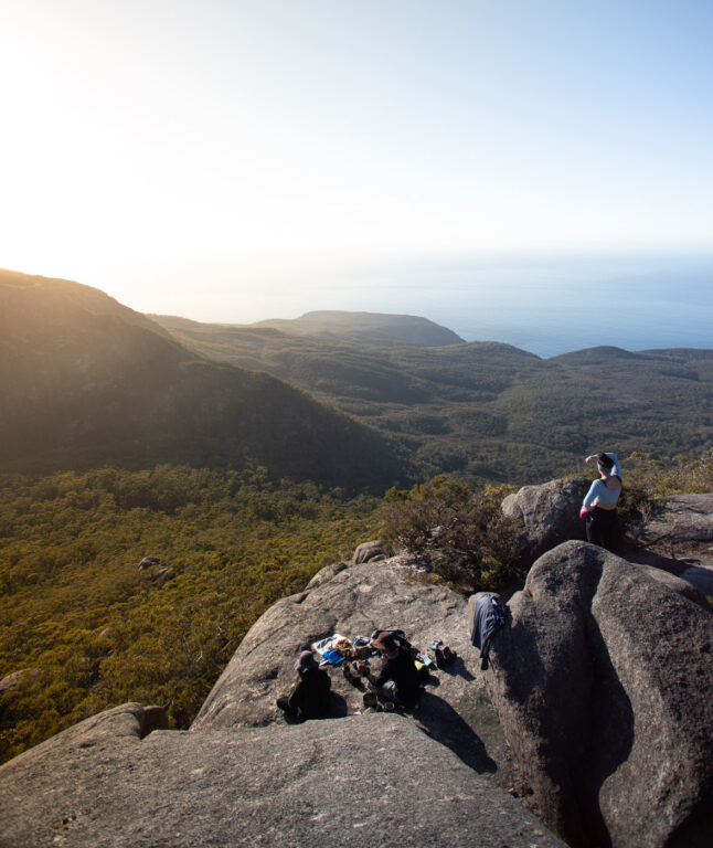
Once at the top, we were rewarded with some of the best views of the Freycinet National Park we'd experienced yet. We had unparalleled views of Hazard's Beach, Mount Graham, the rugged, southern Freycinet coastline and of course, Wineglass Bay and the Hazard's range in the distance. We spent more than an hour at the peak admiring the view and enjoying a hot porridge breakfast and coffee.


Mount Graham
After resting the legs and enjoying the morning view at Mount Freycinet summit, it was time to continue on the Freycinet Peninsula Circuit! Admittedly, it's a little disheartening knowing that you have to descend all the way back to the saddle just to gain roughly the same elevation again.

Luckily, the route up Mount Graham is much gentler, with little to no scrambling required. The view from the top is similar to what's on offer at Mount Freycinet, just a couple dozen metres lower.


The Quartzite Ridge to Wineglass Bay
The track onwards over the so-called Quartzite Ridge is clear from the top of Mount Graham. It follows a carved route over the flat ridge and through low heathlands. This stretch of the Freycinet Circuit was one of my personal favourites as we had great conditions with views across the entire peninsula. However, I'd imagine that this part would be somewhat unpleasant in wet and windy weather since it's largely exposed.

Soon enough, the track winds back down into dense eucalypt forest, descending down the ridge towards Wineglass Bay. Expect roughly 6 kilometres from Mount Graham to the beach, which took us roughly two hours including a brief stop.


Wineglass Bay Beach
There's no arguing the fact that Wineglass Beach is one of Australia's most beautiful beaches, just don't expect any wine. Upon arriving, you'll notice that there's another composting toilet as well as a flowing creek at the campsite. We took this opportunity to answer nature's call and fill up our drink bottles.

After a hefty morning that covers most of the ascent and descent of the entire Freycinet Peninsula Circuit, we were a little sore. So, we spent an hour at Wineglass Bay swimming and eating lunch. Once we had recovered, it was time to walk the length of Wineglass Bay back towards the Isthmus Track.


Of course, it's possible to call the walk early here by taking the 1000 steps back up to the car park. However, we certainly weren't prepared to call it quits early.
Hazards Beach Circuit Back to the Carpark
Instead, we finished the Freycinet Peninsula Circuit by taking the short and pleasant Isthmus Track for a second time towards Hazards Beach.

This time, we turned right once we got to Hazard's Beach towards the northern end. While it might seem like a long detour back to the car park, this loop is actually a much more enjoyable way to end the circuit. The trail follows a beautiful coastal, rocky track that undulates lightly and offers great views out to sea.


The Hazards Beach Circuit is a popular track for day-walkers who are looking to see more than just the typical Wineglass Bay lookout walk. Along the way, there are beautiful secluded coves with crystal-clear water and orange, lichen-covered boulders. The track makes its way around the coast, forming a ring around Mount Mayson before connecting back to the start of the Wineglass Bay lookout track near the carpark.

Finishing the Freycinet Peninsula Circuit Hike
And, just like that, the Freycinet Peninsula Circuit, one of Tasmania's most scenic multi-day hikes comes to an end. As I mentioned, following our plan results in a rather lengthy second day. The split ended up being:
Day 1:
- 19.8 kilometres (including 8 KM return to Bryans Corner from Cooks Beach)
- 5 hours moving time
- 345 metres elevation gain (nearly all on the way up to Wineglass Bay lookout at the start of the walk
Day 2:
- 26.4 kilometres (including Mount Freycinet summit)
- 9 hours moving time
- 1400+ metres elevation gain
Check out our hike and map data on Strava.
HEADING TO MARIA NEXT? DON'T MISS: Maria Island Tasmania: 15 Incredible Things to Do
Where to Stay Near Coles Bay For Walks in Freycinet
- Picnic Island - Ever wanted to stay on a private island? What better place to do so than on Picnic Island, a beautiful island gem just off Coles Bay. Visitors will have the entire island to themselves with rustic waterfront cabins and a fully-equipped kitchen and living area.
- Freycinet Lodge - Located in a waterfront location within Freycinet National Park, Freycinet Lodge offers luxury cabin-style accommodation, two restaurants and a bar. You’ll also get a buffet breakfast included. This is one of the best-located spots to begin your Freycinet National Park walks.
- Eagle Peaks - Another great option is Eagle Peaks, which has good WiFi and free private parking near Coles Bay. This is a unit-style accommodation option featuring a dining and seating area, a fully-equipped kitchen, and great scenery at your doorstep.

Resources: Things to Know Before You Hike the Freycinet Circuit
As promised at the start of this hiking guide to the Freycinet Peninsula Circuit, I've included this short but useful section as a resource guide for those planning the trek.
More Must-do Experiences in Freycinet
- Wineglass Bay Cruise - Experience the unique beauty of Freycinet NP onboard this scenic boat trip with Peniccott.
- Freycinet & Wineglass Bay Active Day Trip from Hobart - a convenient way to explore the hiking trails and sweeping lookouts of Freycinet on an active day trip from Hobart.
- Wineglass Bay Scenic Flight - a once-in-a-lifetime experience flying over the incredible Wineglass Bay– surprisingly affordable too!
Campsite Access and Information
There are three campsites accessible on the Freycinet Circuit. There are:
- Hazards Beach Campsite (Promise Bay), located at the southern end of Hazards Beach
- Cooks Beach Campsite, located at the southern end of Cooks Beach
- Wineglass Bay Campsite, located at the southern end of Wineglass Bay
All of these walk-in only sites are completely free. Also, each has composting bush toilets. In reality, these are actually "hybrid" toilet systems, which is a drop-style toilet with composting waste. This means there is no flush and you need to throw the supplied husk on your number twos.
The only campsite with water tanks is the Cooks Beach Campsite. The water is found in one of six rainwater tanks attached to Cooks Hut, about 100 metres inland on a track from the beach. However, this water is not guaranteed and the tanks can dry out in summer.
There are also no fires permitted in Freycinet National Park. This means that you will need to carry a hiking gas stove if you plan on cooking.
Ross River Fever
Cases of Ross River, a mosquito-transmitted disease have been found in Freycinet National park. It's a good idea to bring mosquito repellent (deet) to prevent bites.
Where to Leave Your Car
All of the walking tracks in Freycinet National Park depart from the same car park at the end of Freycinet Drive. Head towards the National Park Visitor Centre from Coles Bay and continue to the end.
The car park is quite large and accommodates big vans and buses. You can leave your car here for the duration of your hike around the Freycinet Peninsula. Just remember to leave your National Parks Pass on the windshield.
National Parks Passes
Since the Freycinet Peninsula Circuit is within the National Park, you will need a National Parks Pass. Hikers can purchase these online or at the Visitor Centre. If you get yours online, you still need to go to the centre to get a receipt to leave on your dash for the duration of the hike.
National Parks Pass Cost:
- 24-hours: $40 per vehicle/$20 per person
- Holiday Passes – up to 2 months: $80 per vehicle/$40 per person
- Annual Pass all parks: $90 per vehicle (up to eight people)
Preventing the Spread of Phytophthora (root rot)
Unfortunately, there is a bit of Phytophthora around in Freycinet National Park. This is an introduced pathogen that attacks the roots of native plants, causing them to die and "rot". As a result, you definitely want to clean your gear and boots before setting off to other parks around Tassie after hiking in Freycinet National Park.
The "Leave No Trace" Principle
There are no bins where you can dispose of your waste on the Freycinet Peninsula hike. This means that you have to follow the leave no trace principle, and pack out all of your rubbish.
Leave no trace means leave no trace. So, if you need to go to the toilet between camps, or if you want to camp at the saddle, be prepared to pack out your human waste too.
Freycinet Peninsula Circuit Packing List
Planning for an overnight hike can be a little daunting, especially if it's your first one. Even then, experienced hikers can easily forget essentials. Therefore, I thought I'd formulate a quick list of must-pack items for the Freycinet Peninsula Circuit.
- A good hiking backpack
- Lightweight food for the duration of the hike (freeze-dried meals, noodles, mac & cheese, nuts, trail mix, dried fruits etc)
- Plenty of water (pack extra in case the creeks and tanks at Cooks Beach are dry)
- Warm sleeping bag
- Sleeping clothes
- Hiking boots or trail shoes
- Socks
- Head torch
- Swimmers
- Toiletries/medication
- Hardshell rain jacket
- UL tent
- Sleeping pad
- UL cookware, gas stove, gas
- Phone (4G available along the coast on both sides)
- National Parks Pass
- Camera

Camping in Coles Bay
For those in caravans or vans, you'll be stoked to find out that there is an abundance of great camping spots in the area. There is an official Freycinet National Park campground. However, this one is always in high demand and there's even a ballot system that operates in peak seasons.
Otherwise, you can try some of the others below:
- Big4 Iluka
- Swan River Campsite
- River and Rocks Campsite (free)
- The campground at Freycinet Paintball ($10)
More Adventures on Tasmania's East Coast
I hope that this hiking guide to completing the world-renowned Freycinet Peninsula Circuit has been useful for you. If you're looking for more Tasmania travel inspiration, make sure to check out some of my other articles below.
Did you enjoy the trek? Let me know or help other hikers out by leaving trail updates in the comments below.