
West Mulgrave Falls is one of Far North Queensland’s most epic waterfalls! This hidden gem is located deep within the Wooronooran National Park and requires a challenging, yet ultra-rewarding hike to reach.
Are you looking for an epic, off-the-beaten-path waterfall with a truly wild rainforest hike? West Mulgrave Falls is easily one of my favourite waterfalls and hikes in Far North Queensland.
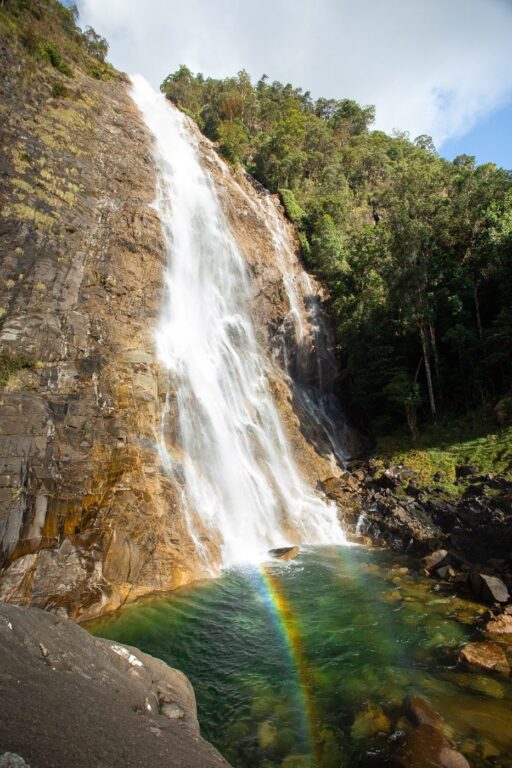
This megalithic cascade is found at the base of a deep gorge within the Wooroonooran National Park. The hike down is fairly strenuous and requires a bit of bush knowledge and navigation skills to complete. However, if you decide you want to give it a go, then it’ll definitely be worth your while! The waterfall is one of the most spectacular near Cairns and includes a deep, aqua-blue waterhole for swimming.
Note: This hike, while not extremely difficult, isn’t suitable for people without plenty of experience hiking in the Australian bush. The track is wild, often overgrown and you can expect plenty of leeches any time of year. There are also creek crossings involved that I wouldn’t attempt following heavy rainfall.

Best Cairns Outdoor Experiences
- Fitzroy Island Full Day Trip - the closest (and cheapest) Great Barrier Reef Island to visit from Cairns. Check out the world-famous famous Nudey Beach and hike to the island summit // Fitzroy Guide
- Daintree & Mossman Gorge Trip - visit the oldest rainforest in the world in the Daintree National Park. Visit Cape Tribulation, Mossman Gorge and get an included cruise.
- Great Barrier Reef by Catamaran - visit the outer reef and snorkel or scuba dive at two pristine reef locations.
- Scenic Helicopter Flight - a once-in-a-lifetime opportunity to see the Great Barrier Reef from above on a scenic helicopter flight from Cairns city.
- ... 7 more top-rated tours here
Travel tip: By far, the best islands for snorkeling in Cairns are the Frankland Islands (pristine reef). There is only one boat trip allowed to stop on these islands and you can book this directly with BackpackerDeals + use code OLLY5 to get $5 off.
Where is West Mulgrave Falls?
West Mulgrave Falls is located within the Wet Tropics, in the incredible Wooroonooran National Park. This park is home to Queensland's tallest mountain; Mount Bartle Frere. The access car park to the trail is approximately 85 kilometres from Cairns.
The waterfall itself is located at the base of a steep gorge, accessed from the Tablelands side of the Bellenden Ker Range. Since West Mulgrave Falls is very little known, there isn't much information online or a Google Maps pin for its location. However, if you follow this hiking guide, then you shouldn't have too much trouble finding it, assuming you are well prepared, experienced and the conditions permit.
How to Get to the Trailhead Car Park
The West Mulgrave Falls hike picks up from the same new car park as the Windin Falls hike. To get here, you'll need to drive up to the Tablelands, and then down a fairly long unsealed road. However, the road is well-graded and in good conditions, a regular 2WD will make it easily.
Quick Navigation to Old Cairns Track: Either paste in the GPS coordinates below to navigate all the way to the trailhead or try “Lamins Hill Lookout” which is the closest named pin.
To get to the West Mulgrave Falls trailhead from Cairns, drive south on the Bruce Highway (A1) towards Gordonvale, where you’ll turn right onto Riverstone Road (State Route 52). Go through the roundabout and follow the winding Gillies Range Road all the way up to the Tablelands.
Just near Lake Eacham, take a left onto Lake Barrine Road and follow this for 6.4 KM, where you’ll need to turn left again onto Topaz Road. This road is very narrow so take care to move aside for oncoming traffic.
After 9.5 km, you’ll reach an intersection near “Lamins Hill Lookout”. Veer left here onto “Old Cairns Track“. Next, just a few hundred metres up the road, you'll come to an obvious fork. Take the right fork and follow this unsealed road for 6.6 km before arriving at a very obvious car par with a sign: "Windin Falls".

Car Rentals in Far North Queensland
Cairns is one of the most popular travel destinations in Australia and car rentals quickly book out! I recommend booking well in advance. I always use RentalCars.com as they compare the widest range of rentals across dealerships in the Far North.
More: Cairns Hikes: 38 Best Hikes
Finding the Trailhead
The trailhead to West Mulgrave Falls begins about 100 metres up the Windin Falls track but is unmarked and quite difficult to spot initially. My best advice is to just follow the wide Windin Falls Track while keeping an eye out for a track in the bush to your right.
This track is often overgrown with grass so it can be difficult to spot. Below, you'll find the GPS coordinates for the West Mulgrave Falls trailhead, and if you keep scrolling, a GPX file that you can follow to help you navigate.
- Car Park GPS Coordinates: 17°21’50.6″S 145°44’59.6″E
- West Mulgrave Falls Trailhead: 17°21'49.3"S 145°45'05.9"E

How I Stay Connected Off-Grid
I've been using the Garmin InReach Mini satellite communicator for all serious treks and expeditions since 2020. It lets me send unlimited SMS anywhere on earth and has an emergency SOS feature that could save your life.
The West Mulgrave Falls Hike
- Hike Distance: 12 km
- Duration: 4-5 hours return
- Elevation: 535 m total gain (most on the way back)
- Difficulty: Difficult
The West Mulgrave Falls hike is considered difficult, both in terms of navigation and physical effort. You'll definitely need to have bush experience and a decent level of fitness to reach this waterfall.
The track is overgrown in sections and is more of a general "route" than a worn hiking trail. However, there are well-marked pink and orange ribbons on the trees that are an essential navigation tool. My advice is to download this blog post for offline use (there is no reception on the track) or download the GPX file below to supplement the ribbons for navigation.
This GPX track is the one that I recorded on my trip to the falls. Tracks and conditions often change in the Wet Tropics, so remember that it should only be used as a general aid and not a primary means of navigation.
The route down to West Mulgrave Falls crosses through dense tropical rainforest before descending steeply down the gorge. Once at the base, hikers will follow a creek all the way to the waterfall.
There are two knee-height creek crossing sections that are fairly easy to manage, assuming regular conditions (can change rapidly). Please don't attempt to cross any rivers following heavy rainfall or any that you aren't comfortable with and only do so at your own risk and judgment.

Hiking Guide
Below I'll detail a route based on experience on the West Mulgrave Falls hike. This might prove to be a helpful aid for you to complete the walk safely.
First Section: Flat But Tricky to Navigate
Begin the West Mulgrave Falls hike by picking up the overgrown, grassy trail on your right, just a few hundred metres from the start of the Windin Falls track. Traverse through the long grass as the track follows the edge of a fenced cattle property.
This first section is one of the most difficult to navigate due to the lack of ribbons. Also, the track pretty much disappears after entering the rainforest, so the GPX map below might be useful here. If you struggle with navigating this section, then it's a good sign that you're ill-prepared for the hike.

Continue following the route through the rainforest on soft and root-filled undergrowth. Keep an eye out for ribbons as you go. This section is fairly dense but you won't need to do much bush bashing. Eventually, the ribbons lead you to a wider, obvious track and then back into the bush.
This first, flat section before the descent is very serene and will offer what I believe to be a real slice of Tropical Far North Queensland's ancient rainforests. After approximately 3 kilometres, you will begin the very steep descent down to the base of the gorge.

The Descent
Prepare your legs up as you make your way down the steep and slippery 40-degree gradient for almost a kilometer as you descend roughly 250 metres to the base of the creek.
This part is easy to follow but there are pink ribbons every 5 metres or so. If you are up to it, continue down and push thoughts of the return climb to the back of your mind, for now.

Following the Creek to West Mulgrave Falls
Once you arrive at the base of the creek, the track opens up to a broad and very scenic rainforest oasis. You can fill your water bottle here (consider filtering) and there is even a small waterfall just a few hundred metres upstream.
Next, follow the pink ribbons to the other side of the creek. There are several spots that were suitable for crossing during my visit. However, we had to take our shoes off as the rocks were too slippery to jump across. Again, it has been raining heavily, or if the creek is flowing too hard, don't attempt to cross.


#1 Water Bottle Filter
Enter the Grayl GeoPress Water Filter & Purifier Bottle! I take this bottle on every hike and use it as my go-to source for filtering water all over the world. I've even used it to drink tap water in India!
// Compare how the GeoPress stacks up against the best water bottle filters on the market.
Once on the other side of this first creek crossing, follow the ribbons into the bush once again. This final push to the waterfall is filled with heavy treefall and wait-a-whiles hanging off seemingly every branch, fern and palm.
Not too long after the first crossing, you'll reach the second. This creek flows directly from West Mulgrave Falls and is definitely more powerful than the first, so take care and don't cross if you are not comfortable with the conditions.
Finally, once you've crossed, continue to follow the pink ribbons, traversing a slippery boulder field with heavy treefall until you finally see the giant, West Mulgrave Falls at the edge of a spacious clearing.

Hike Data & GPX File
Below is a GPX map recorded by my Garmin watch and shows the route that I took down to West Mulgrave Falls. You can download the file by clicking the link below.
This resource will be very helpful in case you lose track of the ribbon trail markers. However, don't rely on it as a primary means of navigation. Also, tracks change and the creek crossing sections that I took might not be suitable when you go. So, use your own judgment and don't blindly follow what you find online.
GPX File: Download
My Strava: Visit
What to Expect at West Mulgrave Falls
As soon as I arrived at West Mulgrave Falls, I was blown away. Having not seen too much information online or even pictures of the waterfall before, the reward was definitely worth the walk!
It's difficult to say how tall the West Mulgrave waterfall is, but I'd say it's at least 60 metres tall. The waterfall crashes violently down the almost vertical cliff face into a deep, aqua-green pool below. There is also a large boulder on the left side of the waterfall that makes a great vantage point. The waterfall pool extends around this boulder in a section that was at least 3 metres deep when I checked the depth. I discovered that it was possible to jump off this boulder into the pool below, but I made sure to do depth checks first as always.

The waterfall pool is the perfect place to swim and cool off before preparing for the steep climb back to the car park. To return, follow the same route as you took on the way in.

Cairns Accommodation Guide – Where to Stay
Visiting Cairns? The best places to stay are near the Cairns Esplanade or on the sunny Northern Beaches. Below are the top 4 options for varying budgets.
- Crystalbrook Riley - If luxury and location are what you're after, you can't beat the Crystalbrook Riley. This is the best 5-star resort in Cairns and features absolutely everything you'd expect from a Crystalbrook resort.
- Fitzroy Island Resort - Sleep out on one of the picturesque Great Barrier Reef Islands at Fitzroy Island Resort. Spending the night on the island can work out cheaper than staying in town and means you get more time to explore the reef, coral beaches and rainforest walking trails.
- Gilligan's Backpackers - The best backpacker option for a great vibe in Cairns. Great place to meet like-minded travelers and has facilities including a pool. air-con, a huge shared kitchen, and a great common area!
- Pepper's Beach Club - stay at the best beach resort in the heart of Palm Cove on the Cairns Northern Beaches!
For a bigger list, don't miss my Cairns accommodation guide or as an alternative stay in FNQ, read my Port Douglas Accommodation guide too.


More Hikes and Waterfalls in Cairns & The Tablelands
I hope you found this hiking guide to West Mulgrave Falls useful in planning your adventures in the Wooroonooran. For more adventure guides, hikes and waterfalls around Cairns, check out the list below.
Otherwise, why not check out this mega-guide to the best waterfalls in Cairns.

R James
Wednesday 12th of May 2021
Strongly disagree with openly publicising routes like this which traverse Wet Tropics wilderness zone and should be for experienced walkers with local guides only. The pink markers are removed periodically because they are unauthorised and not legal. Please stop trying to popularize every last remote walk to the point that no remote experience opportunities remain in the Wet Tropics. Windin has been popularized to the point it is unenjoyable now for most local hikers, don't do the same to West Mulgrave.
Olly Gaspar
Thursday 13th of May 2021
First of all, I appreciate your input and I can sympathise with your position. However, my intent definitely isn't to popularise a hike or waterfall of this nature. My goal is to help people (locals included) who are already interested in exploring this beautiful region do so safely while making the most of the experience.
To your point, West Mulgrave will never be another Windin Falls because those that are ill-prepared will be shaken out on the first section requiring navigational skills. Besides, popularisation on that scale doesn't happen off the backs of independent adventure writers, it requires millions of dollars of Parks and tourism investment into track development and promotion.
Also, while I do agree that you need solid bush experience to traverse this route (stated many times throughout the article) I disagree with your view that a walk like this should be hiked by people with guides only. To be honest, I've come across many people with similar input as you all around the world. I've found that most of the time, they're trying to push an agenda of "exclusivity", perhaps to elevate their ego or somehow contain nature trails within their own cliques and walking groups. The Wet Tropics is there for everyone to enjoy, respect and preserve. The more people who get to experience its brilliance, the louder the voice of conservation grows.
To those reading this, while the difficulty of this wilderness route should be respected, you don't require a guide to visit West Mulgrave Falls and you certainly don't need the permission of R James to attempt it.
suzanjack
Thursday 8th of October 2020
Very nicely said your mind is as beautiful as your photography Keep up the beautiful work!I love it , Thankyou for sharing with us.