
The Devils Thumb hike is a long and steep hiking trail located in Mossman Gorge, Daintree National Park. This strenuous hike leads to a tremendous granite feature known as Devils Thumb or Manjal Jimalji. This exposed boulder offers unparalleled Coral Coast views from Cape Tribulation to Cape Grafton.
In terms of rainforest hikes in Mossman and the Daintree National Park, none are as diverse or as rewarding as the Devils Thumb hike. This 10.6 kilometre track climbs steeply up a section of the Main Coast Range, with well over 1200 metres of elevation gain through dense tropical rainforest.
In this guide, I’ll answer all of the questions you might have about hiking to Devils Thumb, including how to get to the trailhead and a step-by-step breakdown of the mission to the top of this epic granite boulder!
- About the Devils Thumb Hike
- Video From the Devils Thumb Boulder
- Getting to the Devils Thumb Trailhead
- Devils Thumb Trail Map
- Devils Thumb Hike – What to Expect
- View from the Devils Thumb Boulder
- Bonus: Devils Thumb Waterfall (Karnak Falls)
- Best Time to Hike to the Manjal Jimalji Trail to Devils Thumb
- Is the Devil’s Thumb Trail Closing?
- More Hiking Guides in Far North Queensland


About the Devils Thumb Hike
Devil's Thumb is a sacred granite boulder that is an obvious feature on the mountain range above Mossman. When you see it from the Captain Cook Highway, it's not difficult to see where they got the name.
Devil's Thumb has long been an important site for indigenous Eastern Kuku Yalanji people. These are the traditional custodians of the land surrounding the Mossman Gorge.
Consequently, the traditional name of this place is Manjal Jimalji in their language. It tells the tale of fire creation, whereby a fire spirit is believed to have taught a tribal warrior the art of making fire by rubbing sticks together at this spot.
The Devils Thumb hike is one of the best hikes in the Cairns region. However, it is also one of the most challenging. The incredible view spanning the coastline is earned after a long and steep, 7-9 hour return walk through dense rainforest.
The Devils Thumb trail is well-marked with pink and orange ribbons. However, QLD Parks recommends bushwalking experience and above-average fitness to complete this hike.

Video From the Devils Thumb Boulder
Here is a quick video showing you how epic the views are once you've made it to the top.
Getting to the Devils Thumb Trailhead
The Devil's Thumb trailhead is located in Whyanbeel Valley at Little Falls Creek, which is just 17 kilometres north of Mossman and 80 kilometres from Cairns.
But, basically from Mossman head north on the Mossman-Daintree Road. After roughly 8 kilometres, you'll reach a strange intersection where you will need to take the left (straight ahead) road.
Continue for roughly 3 kilometres before turning left onto Whyanbeel Road.
Next, continue for a further 4 kilometres and take the second road on the left (Karnak Road) after crossing the bridge over Whynanbeel Creek. Continue down this road until you reach a cattle grid beside a visible trail sign.
You can park your car in the space next to the sign or just off the road on the left before the cattle grid.
GPS Coordinates: 16°23'37.5"S 145°20'01.0"E
Make sure to check for any QLD Parks Alerts before heading out to the trailhead. Once you get out here, you'll likely not have any phone reception until you make your way to the summit.

Tip: Remember to bring at least a couple of litres of water per person. There's only one spot to refill your bottles once you start the ascent and this is roughly halfway up the range at a waterfall (more info below).

#1 Water Bottle Filter
Enter the Grayl GeoPress Water Filter & Purifier Bottle! I take this bottle on every hike and use it as my go-to source for filtering water all over the world. I've even used it to drink tap water in India!
// Compare how the GeoPress stacks up against the best water bottle filters on the market.
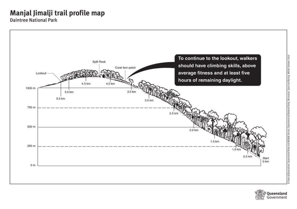
Devils Thumb Trail Map
Below is an elevation map that is useful for planning the hike and estimating distance.
GPX File
Here's the GPX file generated from my Garmin watch. You can download the file using the link below the map to help with navigation using your GPS watch or phone.
GPX File: Download
My Strava: Visit
Remember to only use this GPS data for a rough route or for elevation profiling. Tracks and routes change regularly and therefore you can't solely rely on a GPX file for navigation.
Devils Thumb Hike - What to Expect
- Hike Distance: Official: 10.6 KM return | Recorded: 14.8 KM (with side-trip to the waterfall)
- Duration: 7-9 hours
- Elevation: Total elevation gain: 1275 m |
Devil's Thumb Elevation: 1190 m AMSL - Difficulty: Difficult
The Devils Thumb hike is an out-and-back trail considered to be a strenuous and difficult hike that takes between 7-9 hours to complete with stops. The track is well-marked with orange and pink ribbons on the trees. However, you'll need to be vigilant in following them as sections are very dense and it can be very easy to get lost.
This track is also quite steep, with some sections of almost vertical root scrambling and some requiring light boulder scrambling. All in all, the Devils Thumb hike is no more challenging than climbing Mount Bartle Frere, but I would say it is more demanding than Walsh's Pyramid and the Kahlpahlim Rock hike.
You don't need climbing experience or gear, but you'll need to be fairly fit and diligent in following the markers. Make sure also to keep an eye on the trail for snakes. Believe me, they are there.
The Ascent to the Coral Fern Patch
From the cattle grid, park your car on the side of the road and follow the directions on the green QLD Parks sign. The first section requires you to navigate your way through a small section of private property, so make sure to be quiet and respectful.
The sign indicates that you should follow the pink ribbons and keep off the wider, private road. We started the Devils Thumb trail well before sunrise, so finding our way through this first section was one of the most difficult parts of the hike for us in terms of navigation.
Soon, you will pop out of the scrub and pass "Little Falls Huts", a beautiful rainforest property beside the creek.
Keep following the pink tree markers leading to the river, which you will have to cross. Although there are some rocks, it's difficult not to get wet, so we decided to take off our shoes and cross the knee-high river to the start of the Devils Thumb walking track.

From here, you'll need to continue for roughly another 3.5 kilometres on a very steep gradient, climbing roughly 950 metres before breaking out of the rainforest at a scenic patch of coral ferns at approximately 1000 m AMSL.


Coral Fern Patch to Split Rock
After resting your legs following the tiring climb, you'll need to continue on for roughly another hour before reaching Devils Thumb (Manjal Jimalji).
Follow the obvious track through the coral ferns, which begins to climb gently and crosses a raised section elevated by an aluminium support.

This section is definitely less steep and quickly tapers off to a flat gradient. However, after re-entering the forest, it becomes very dense and you'll need to be careful to follow the coloured ribbons on the trees.

After approximately 800 m, you'll come across a huge split boulder which the trail leads into. This section requires a bit of scrambling up the granite boulders, which shouldn't be very difficult at all for anyone who's made it this far.


50+ More Cairns Bucketlist Items
- Visit the Cairns Islands
- Kuranda Railway & Skyrail
- Rusty's Markets
- Day trip to Cape Tribulation
- ... +51 more things to do in Cairns!
Split Rock to Devils Thumb (Manjal Jimalji)
Following split rock, you'll be at the highest point of elevation for the Devils Thumb hike at 1190 m AMSL. From here, the track continues but dips back down the other side of this ridge for roughly another kilometre.
There won't be any question about whether you've reached Devils Thumb or not. You'll immediately see the towering boulder suddenly appear in front of you.
To reach the top of the boulder, follow the ribbons, which lead to a makeshift "bridge" that somebody has kindly supported using straps and ropes. Scramble up the dirt mound, cross the bridge, and you'll have reached the end of the Devils Thumb hike, where mind-blowing views await.
Update: I've been told that this bridge has been taken down for some reason. If you head up and find the bridge gone, please take a photo and let me know so I can add it to the blog.

To return, climb down the Manjal Jimalji rock and follow the same track back to Little Falls Creek. There is also an option of stopping by the waterfall (below) on the way back down.

View from the Devils Thumb Boulder
In my opinion, the views from Devils Thumb (Manjal Jimalji) are one of the best in Far North Queensland.
On a clear day, you'll get a view north all the way to Mount Sorrow and Cape Tribulation. To the south, views span as far as Cape Grafton, with Port Douglas, Palm Cove and Double Island visible along the coast.


Out to sea, you'll get clear views of the Low Isles and the contrasting coral shades of the Great Barrier Reef.
The entire length of the Daintree River is also visible as it snakes its way from the rainforest to its sand-spit bar.
Inland, views include sections of ranges and valleys of the Mount Windsor National Park, and of course, the world's oldest rainforest in the ancient Daintree National Park.


Bonus: Devils Thumb Waterfall (Karnak Falls)
Although there are a few guides out there to the Manjal Jimali trail and Devils Thumb lookout, I haven't seen one mention the waterfall that is accessible from the halfway point on the ascent to the coral fern patch.
It's actually quite difficult to miss the fork in the track at roughly 400 m elevation (2.5 km distance), and the sounds of crashing water seem it fairly obvious that there was a waterfall here.
If you follow the left path, you'll quickly reach the creek, which can be followed downstream by the pink ribbons to the top of the waterfall. It's a fairly steep descent but it's only 200 m from the main track so I thought it was worthwhile.

The creek and waterfall are scenic and make for a great spot to fill your bottles or cool off. From the top of the waterfall, you'll get open views out to the ocean. Just remember to follow the signs, stay off the slippery rocks, and don't try to walk on the surfaces near the edge as it's very dangerous.


The official name for this waterfall is Karnak Falls, and its height is 80 metres.
Best Time to Hike to the Manjal Jimalji Trail to Devils Thumb
By far, the best time to hike in Far North Queensland is between the months of May to September (dry season). During this time, the weather is cooler, and the chance of rain is lower. If you're hiking during the wet season, expect slippery surfaces, wet, boggy trails and more leeches.
Tip: Depart at first light or just before sunrise on the Devils Thumb hike to get the best light at the top. This way, you'll get less afternoon haze and ensure you have adequate remaining daylight for the return trip.
Cairns Accommodation Guide – Where to Stay
Visiting Cairns? The best places to stay are near the Cairns Esplanade or on the sunny Northern Beaches. Below are the top 4 options for varying budgets.
- Crystalbrook Riley - If luxury and location are what you're after, you can't beat the Crystalbrook Riley. This is the best 5-star resort in Cairns and features absolutely everything you'd expect from a Crystalbrook resort.
- Fitzroy Island Resort - Sleep out on one of the picturesque Great Barrier Reef Islands at Fitzroy Island Resort. Spending the night on the island can work out cheaper than staying in town and means you get more time to explore the reef, coral beaches and rainforest walking trails.
- Gilligan's Backpackers - The best backpacker option for a great vibe in Cairns. Great place to meet like-minded travelers and has facilities including a pool. air-con, a huge shared kitchen, and a great common area!
- Pepper's Beach Club - stay at the best beach resort in the heart of Palm Cove on the Cairns Northern Beaches!
For a bigger list, don't miss my Cairns accommodation guide or as an alternative stay in FNQ, read my Port Douglas Accommodation guide too.


Is the Devil's Thumb Trail Closing?
The Devi's Thumb summit has always been a spirtual and culturally significant site for the Eastern Yalanji people. Recently they have announced that they will be installing a restricted access sign near the top of the trail, just at the boulder.
As a result, I will not be returning to this trail since it would be against the wishes of the rightful owners of this land. However, I believe that many people will still attempt this hike, and therefore I believe it is important for me to keep this blog post live for the safety of hikers.
More Hiking Guides in Far North Queensland
I hope that this guide will be useful in planning your day trip on the Devils Thumb hike (Manjal Jimalji). For more hiking guides and adventure travel ideas, take a pick from the list below.
Otherwise, check out this comprehensive guide to the best waterfalls in Cairns.

Lena
Sunday 8th of May 2022
I just hiked there a few days ago! Thank you for your post. Unfortunately, weather on the top was cloudy! However I had nice view from fern secion. And yes the bridge is still there!
Olly Gaspar
Sunday 11th of April 2021
Thanks Jared, enjoy!
Jarred
Monday 24th of August 2020
Heading out tomorrow morning and just wanted to say thanks! This is easily the most comprehensive guide on Devil's Thumb I could find online