
An up-to-date hiking guide to Federation Peak in Tasmania. Follows a detailed trip report of our recent winter summit attempt from Farmhouse Creek. A useful guide for those attempting the Federation Peak hike, Australia’s most notorious mountain.
With imbecilic repetition, I rip my soggy boot from the cold, muddy depths before wincingly plunging it back into the soupy muck below. My eyes reach for the prize in a feeble attempt to muster motivation but thick, slimy vegetation hinders my vision. I attempt to pluck a leech from my cheek but the cold has taken the dexterity from my fingers long ago. Perpetual rain invades every seam of my jacket, creeping in as if to slowly drown me through my wrinkled skin.
If that snippet of an account doesn’t deter you, then Federation Peak’s summit is as fixed in your eyes as it was for me.
My partner Haylea and I attempted the Federation Peak summit over a 3-day return itinerary from Farmhouse Creek at the beginning of Winter 2021. Unfortunately, we had to turn around close to the beginning of the final ascent due to dense cloud and slippery, icy conditions.
Therefore, I can't comment much on the final ascent in this guide (it's steep) because we didn't actually make the summit. However, to help other hikers out, I've written this guide which encompasses the gruelling traverse from Farmhouse Creek to Berchevaise Plateau, just below the summit of Federation Peak Tasmania.
Important: Federation Peak is one of Australia's most dangerous hikes. Although officially, you don't need to pack-haul or bring ropes or any climbing gear, this one certainly pushes the limits for a "trekking peak". The final ascent is very exposed and there is a sheer 600-metre drop below. Also, the hike in requires bush knowledge, navigation experience and is honestly more of an outdoor survival feat than a hike.
I am in no way trying to popularise this walk or encourage anybody to attempt it if they are not prepared. My goal is to help those already committed to the challenge do so safely.


About Federation Peak
- Federation Peak height: 1274 metres
Federation Peak is the iconic Tasmanian spire mountain located deep in the Southwest National Park wilderness. Nicknamed Feddy or Fedder, this 1274 metre peak is nowhere near the tallest mountain in Tasmania but holds the fiercest reputation.
A testament to the difficulty of the hike to the summit is such that it took over 50 years for the first westerner to reach the top after its first sighting. Sir Edmond Hillary even named it "Australia's only real mountain".
The peak is a picturesque spire, or obelisk, as it was once named by the original western surveyor James Sprent. There has even been a documentary about the mountain, that follows a team of climbers attempting the summit via the "Blade Ridge" in the middle of Winter.

Where is Federation Peak
Federation Peak marks the end of the Eastern Arthur's Range in Tasmania's raw and untamed Southwest National Park. The peak is roughly 90 kilometres southwest of Hobart.
While the final ascent is notoriously steep and exposed, reaching the base requires a long, gruelling slog through muddy and unforgiving terrain.

Car Rentals in Tasmania
Unfortunately, the cost of bringing your own car on the Spirit of Tasmania has skyrocketed in recent years.
Now, it is usually cheaper to rent a car on arrival. I recommend using RentalCars.com in Tasmania to compare rates for different vehicles across dealerships.
(Rentals are limited in Tasmania so it's a good idea to book in advance).
How to get to the Federation Peak Trailhead
Federation Peak can be reached as part of the Eastern Arthurs Traverse from both directions. However, for the purpose of this guide, I'll detail the out-and-back route from the trailhead at Farmhouse Creek.
The trailhead begins from Farmhouse Creek, which is a small cleared space to park your car at the end of Picton Road.
To get here, you'll need to drive to the nearest township of Geeveston and then turn onto Arve Road, a well-maintained and sealed, winding road leading to the Hartz Mountains and Tahune Adventures. The turnoff onto Picton Road is near the end of Arve Road on the left, just 1 kilometre from Tahune Adventures.
Picton Road is unsealed but generally quite well-maintained as there are plenty of logging spurs off this road. You will need to drive all the way to the end (roughly 22 kilometres) to reach Farmhouse Creek. You don't need a 4WD to get to Farmhouse Creek and we made it in our big van (although very slowly, I wouldn't recommend it).
There is adequate parking space for roughly 6-8 vehicles at a small clearing at the end of Picton Road (Farmhouse Creek). You can leave your car here for free.
- GPS Coordinates for the trailhead: 43°13'54.1"S 146°40'05.1"E
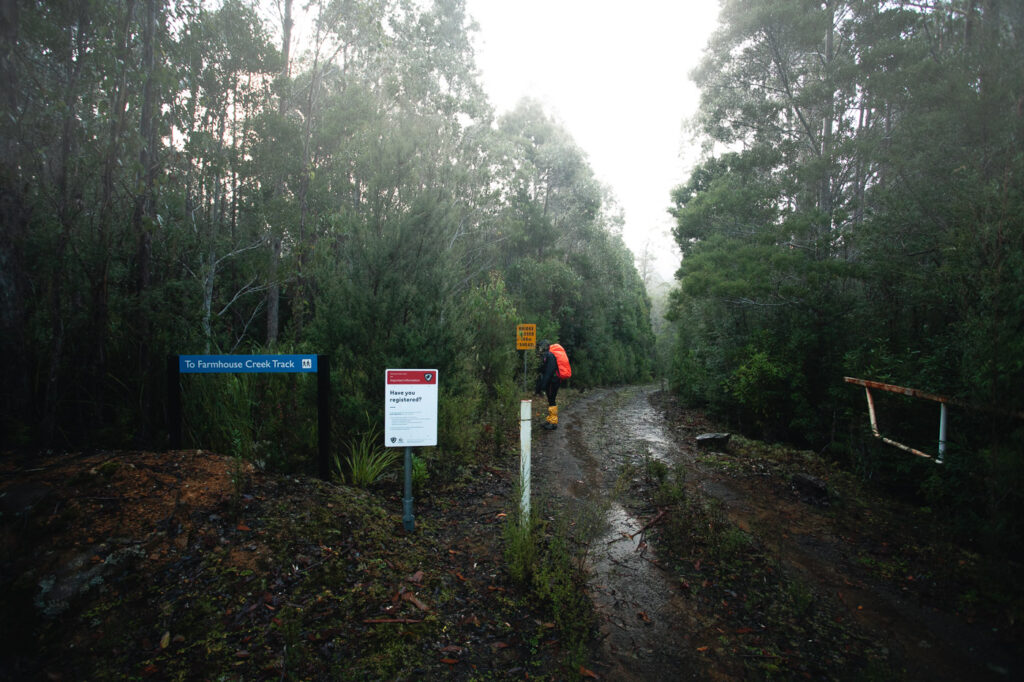
The trailhead for the Federation Peak hike begins by crossing a bridge over Farmhouse Creek and is marked by a "Southwest National Park" sign and boot-cleaning station.
The first section of the track is named "Farmhouse Creek Track" or the "Eastern Arthurs Traverse Track".
Federation Peak Hiking Itineraries
As mentioned before, there are several ways to hike Federation Peak. The recommended itinerary is five days but I'd say this is a bit long. We set out in Winter with the goal of summiting Federation Peak and returning to Farmhouse Creek in three days. I'd say that this is a good amount of time at a decent pace (weather permitting).
Below are some itinerary options as well as exactly what we did:
5-Day Itinerary:
- Day 1: Farmhouse Creek to South Carcroft River Crossing
- Day 2: South Carcroft River Crossing to Cutting Camp
- Day 3: Cutting Camp Berchevaise Plateau via Federation Peak
- Day 4: Berchevaise Plateau to South Carcroft River Crossing
- Day 5: South Carcroft River Crossing to Farmhouse Creek
This itinerary is very doable but it is quite easy to pack much more in a day if conditions are good. Trust me, you don't want to be out there for five days. Below is what we planned to do but only got as far as Berchevaise Plateau.
Our Planned 3-Day Itinerary:
- Day 1: Farmhouse Creek to Cutting Camp
- Day 2: Farmhouse Creek to Berchevaise Plateau via Federation Peak
- Day 3: Berchevaise Plateau to Farmhouse Creek
Unfortunately, as mentioned, we had to back after the plateau since conditions didn't allow us to summit. So, here's what we actually did:
- Day 1: Farmhouse Creek to Cutting Camp
- Day 2: Cutting Camp to Cutting Camp via Berchevaise Plateau
- Day 3: Cutting Camp to Farmhouse Creek
For those attempting the mission in Spring or Summer (daylight savings), then two days is also possible and has been done by a few people including Mac from Halfway Anywhere. He's also got a really good guide you can find through that link.
Honestly, I think two days is the limit for this one. I wouldn't recommend anyone attempt to summit Federation Peak from Farmhouse Creek and return on the same day.

How I Stay Connected Off-Grid
I've been using the Garmin InReach Mini satellite communicator for all serious treks and expeditions since 2020. It lets me send unlimited SMS anywhere on earth and has an emergency SOS feature that could save your life.
The Federation Peak Route From Farmhouse Creek
- Hiking Distance: Official: 40 km
Recorded to Berchevaise Plateau return: 64.92 km - Duration: 2-5 days
- Elevation: Total elevation gain roughly 1800 m
Federation Peak: 1274 m AMSL - Difficulty: Very Difficult, experience mandatory;
Tas Parks: T5 level - wilderness track
With all of that out of the way, let's get into the actual details about the hike out to Federation Peak Tasmania.
If I can paint a picture of this hike in a few words, I'd say it's a miserably wet, muddy slog. The majority of the track is mostly ankle to knee-deep mud through dense terrain.

Do yourself a favour, don't try to get around the mud. The thin muddy line is often the only way to tell you're on track. You will get half-submerged in mud eventually, there's just no way around it. Time is crucial on the Federation Peak hike, push on and just wade through. There are also loads of blowdowns and windfall and much of the track is overgrown so there's that to deal with too.

While there are coloured ribbons in the trees along the way these are very sporadic and almost never there when you actually need them. You're going to need a map (Tasmaps) and I'd recommend a compass to get back onto the track if you lose it (like we did a few times).
Additionally, a satellite phone is definitely advised as there is absolutely no phone reception anywhere out there. I use Garmin's InReach Mini.
You can also download a GPX file here (not mine). However, it goes without saying that this should not be used as a main source of navigation. The Maps.Me track is a decent tool to find the track but very approximate and out by more than 50 metres in many sections.
Campsites on the Federation Peak Rote
There are multiple suitable campsites along the way. Below are the locations (approximate) of each. Note that only the South Carcroft River Crossing and Berchevaise Plateau have wooden platforms to pitch a tent onto.
Also, I apologise if the locations don't match the names for Crest Camp, Forest Camp or Paperbark Camp. There are no signs for any camps along the way but I marked the coordinates of where I thought each was by referencing the map using my InReach Mini. Whether or not the name is correct, all three coordinates for these specific sites mark a spot where there was flat ground for camping during my attempt.
- South Carcroft River Crossing: S 43°15'42.0372" E 146°34'53.7888"
Updated after 2019 fires: Now there are 3 wooden platforms 100 metres from the river on the eastern side: - Crest Camp: S 43°15'34.2576" E 146°31'50.4948"
- Forest Camp: S 43°15'42.1308" E 146°32'08.6640"
- Paperbark Camp: S 43°15'38.4984" E 146°31'33.0960"
- Cutting Camp: S 43°16'03.2016" E 146°30'16.0992"
- Bechervaise Plateau: 43°16'08.4"S 146°28'52.5"E


Farmhouse Creek Trailhead to the First River Crossing
The first section of the Federation Peak hike begins by crossing a bridge and then immediately ducking into dense forest. The first section is flat and quite easy to follow as it makes its way beside Farmhouse Creek before eventually crossing it (over a log) approximately 6 kilometres in.


The Ultimate Tasmania Travel Resource
Looking for more Tasmania travel guides & adventure inspiration? Below are my most comprehensive blog posts that will serve as a great free resource for your trip.
Weather is notoriously unpredictable in Tasmania, especially in Southwest National Park. We found this out the hard way when we arrived at Farmhouse Creek to sleep in our van the night before the Federation Peak hike.
The prediction from BOM was clear skies and almost no wind. Instead, it rained consistently, the entire night and continued well into the first day.
Consequently, we had to face miserable conditions from the get-go. The track was flooded in many sections and the mud just got deeper and deeper as we continued.

We still managed a decent pace for the first stretch. It took us roughly 2 hours to reach the first river crossing, where the track diverts over Farmhouse Creek via a large fallen tree.

The Climb Up South Picton Saddle
Next was the steady ascent up the South Picton Saddle. Following the first river crossing, the track narrows and gets a whole lot muddier. This section was quite hard to follow since it was completely overgrown in some parts.

The incline isn't too bad but the mud makes things slow going. There are also a lot of fallen trees which you'll need to go around, jump over or climb under.
Once we neared the top of the saddle, we approached a fork (S 43°15'08.4672" E 146°36'41.3748). Keep right here and don't descend on the left. This is the Lake Sydney track and leads to Mount Bobs (13.6 KM return to the fork).


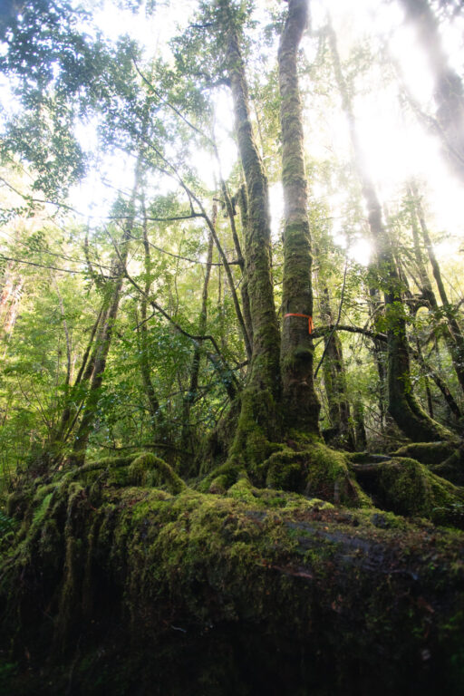
Soon enough, we were at the top of the South Picton Saddle, where the vegetation opened up under beautiful myrtle forest. I quickly snapped a few photographs here but continued on quickly, descending the other side of the saddle (much steeper).


#1 Water Bottle Filter
Enter the Grayl GeoPress Water Filter & Purifier Bottle! I take this bottle on every hike and use it as my go-to source for filtering water all over the world. I've even used it to drink tap water in India!
// Compare how the GeoPress stacks up against the best water bottle filters on the market.
Approaching the bottom, the vegetation quickly changes from wet temperate rainforest to dry, burned sclerophyll forest. This is a section that was heavily damaged from the 2019 bushfires.
The change in vegetation didn't settle the mud though, which only got worse as we levelled out onto the Carcroft Valley approaching the South Carcroft River.


The South Carcroft River Crossing
The area surrounding the South Carcroft River was also damaged during the fires. As a result, the old camp is closed by Tasmanian Parks. Instead, they've constructed three new wooden platforms approximately 100 metres from the river on the eastern side (before the crossing).
We were making decent time considering the miserable conditions, arriving at the South Carcroft River crossing roughly 5 hours after departing Farmhouse Creek. We knew we still had a fair distance to go until we reached Cutting Camp so we didn't wait around and kept wading through the mud.
Due to all of the rain, the river was running pretty hard. Luckily, there was another large tree that had fallen where we could cross. Almost immediately after crossing, the track opens up to the buttongrass plain of the Carcroft Valley.

Carcroft Valley to Cutting Camp
While from afar this stretch looked easy, it actually ended up being one of the muddiest and most frustrating sections of the Federation Peak hike. Heading west, the track starts flat then begins undulating sharply as you ascend and then descend several times through interchanging terrain of dense forest and open plain.

On the final ridge, we got our first view of Federation Peak in the distance. The going was very slow and extremely muddy. Daylight was also quickly slipping away from us so we didn't exactly stop to admire the view.

Once levelled out, the track joins up to parallel the Carcroft River. There were a few unnamed creeks to cross along the way, one which was particularly heavy-flowing (water level past our waist).
We lost the track a few times on this section. This was very frustrating as it meant we had to continue for the last hour soaked and freezing in the dark with only our head torches. Not a spot we wanted to be in on day one.
However, there were several suitable (although very wet) campsites on this section that we could have stopped at. But, after regaining the track we had the confidence to push on towards Cutting Camp, which we thought might be a little drier (we were wrong).
My advice for the section between the South Carcroft River Crossing and Cutting Camp is to stay close to Cacroft River. Although the track moves in and out, it seems to stick close to the river for the majority.
We arrived at Cutting Camp at around 6 PM. This meant that it took us nearly 4 hours to cover 6.5 kilometres! I can put this down to losing the track a couple of times and trying to find suitable spots to cross the creeks in the dark. In decent conditions, you can cover this section in around 2 hours at a fast pace, which we did on the return.
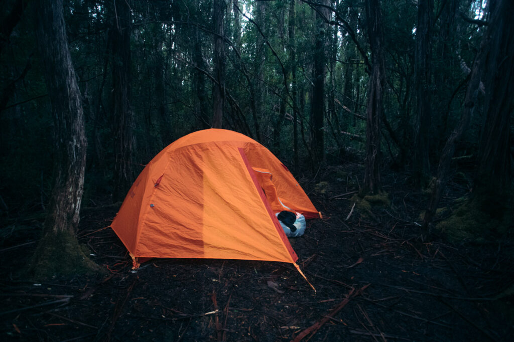
Cutting Camp has several flat areas in a cleared, mossy forest beside Cherry Creek (your water source). However, due to the heavy rain, the ground was very boggy and swampy.
Climbing Moss Ridge to Berchevaise Plateau
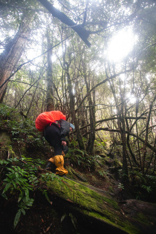
Disappointedly, unforecasted, light rain continued to fall all night. We packed up the tent at first light and continued on for the notorious climb up Moss Ridge in the newly-dampened swamp.
The track begins by crossing Cherry Creek and then immediately begins ascending. Climbing up Moss Ridge is very steep and involves muddy, vertical root climbing. There are no markers on this section but navigation is fairly easy. There's simply only one way to go.

Although the distance from Cutting Camp to Berchevaise Plateau is less than 3 kilometres, it's very slow going. Don't expect to cover this distance in less than 3 hours.

About halfway to Berchevaise Plateau, you gain the ridge where we got great views of Federation Peak. It felt like we were getting close to the final ascent but first we had to go back down the other side, come back up the ridge and then repeat that twice.

In my opinion, Moss Ridge is in bad shape. The track involves several thin sections of soft, eroding peat that is only just hanging on. It's clear that much of the track has completely eroded and many of the roots you need to climb your way up have snapped off.

There is one particular section that I really think doesn't have much life left. It looks like the entire face has eroded underneath it and the track here is simply just a chunk of soft, squishy peat held to the rock by a few roots. You'll know what I mean when you get to it.
Someone has wedged a piece of timber between the rock and a small tree that you can use to get over this bit. A little sketchy but doable.

From this section, it's a bit more of the same up and down before you reach Bechervaise Plateau, albeit less steep.
Our Winter Attempt at the Federation Peak Summit
The weather seemed to finally be on our side as we made our way over Moss Ridge. Besides some lingering clouds, we were confident that we could make the summit.
However, our confidence quickly waned. More clouds gathered as we climbed and conditions were very slippery. Fresh snow blanketed much of the face which made finding the right way up difficult. We didn't even make it to Chuckstone Gully, which is apparently the steepest part of the ascent.
In the end, we abandoned the attempt to summit Federation Peak. We were still soaked to the core, cold and a bit disoriented. Not a great condition to be in when attempting to climb one of Australia's most dangerous hiking peaks. Although it certainly hurt our ego to turn back after enduring so much hardship, we knew that it was too dangerous for us to continue, especially since we were struggling with the easier sections.
We ended up descending back down Moss Ridge and again staying at Cutting Camp. The next day, we departed at roughly 6 AM and made it back to the car park by 3:00 PM. Needless to say, we were very eager to get out at that stage so we absolutely pumped it back at a much swifter pace than on the way in.

My Apologies
Looking back, I can definitely say that we made the right move to call it quits. One wrong move up there and you're toast. I apologise for not being able to help with the final ascent but there are a few other blogs out there that cover it including Halfway Anywhere (above).
I juggled with the idea of posting a hiking guide to Federation Peak since we didn't really make the summit. But, in the end I thought it would be useful to post an updated account of our experience in Winter. I thought this would be especially helpful since much of the track has changed since the big fires in 2018.
I hope you found this article helpful!

More Hikes & Adventures in Tasmania
That wraps up this hiking guide to Federation Peak Tasmania. Again, I really hope that you found it useful and that it aids in your preparation. Good luck and I wish you excellent weather.
Before you go, if you're looking for more Tasmanian hiking guides or adventure inspiration, make sure to check out some of my other articles below.