
The Mount Fox route is arguably one of the toughest yet most rewarding day hikes on the West Coast of the South Island, New Zealand. If you’re after the best viewpoint of the Fox Glacier, then this is the one.
The Mount Fox Route was one of my personal favourite hikes on the South Island of New Zealand. It’s challenging, steep and incredibly rewarding.
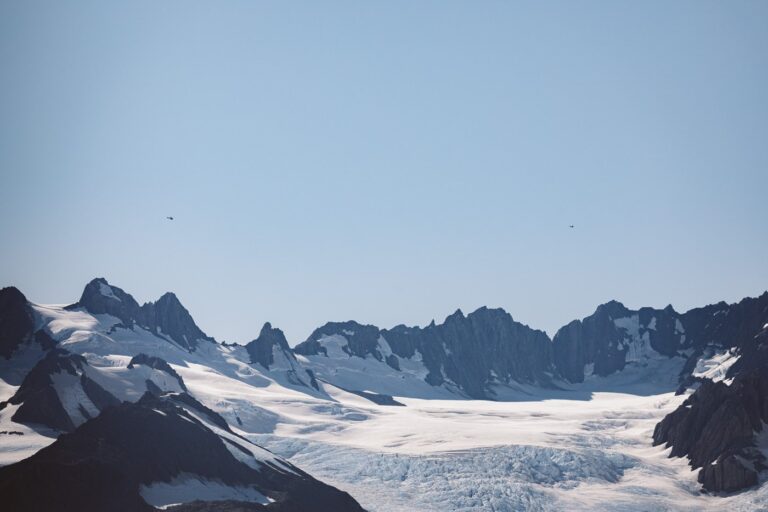
After hours of climbing almost vertically, the sunrise views across the glacial valley to Aoraki (Mount Cook) and the Fox Glacier simply can’t be beaten. They say that this is the best Fox Glacier viewpoint in the area without getting a helicopter flight.
But, you better be prepared to earn it.

About the Mount Fox Route Hike
The Mount Fox Route is a challenging hike that climbs steeply through dense native forest before breaking through at a trig point just underneath the Mount Fox summit.
It is located in the Westland Tai Poutini National Park in the West Coast Region of New Zealand's South Island.
The Mount Fox Route is different from a regular DOC hiking or tramping "track". The key difference is that on New Zealand "tracks" you'll be able to follow a warn trail the entire way. Routes are different because hikers will need to navigate along the route, following markers on trees and on poles.
This navigation can get tricky at times. And, therefore this hike is aimed at those with bush and New Zealand mountain experience.


How to Get to the Mount Fox Trailhead
The Mount Fox hike trailhead is located on the Haast Highway, near Thirsty Culvert, approximately 3 KM south from the Fox Glacier township.
Once you arrive, you'll notice a parking area on the right side of the road. You'll see the small signpost on the opposite side of the road leading directly into the scrub.
I've pinned the exact location on the map below.
- GPS Coordinates: 43°28'49.2"S 169°59'38.2"E

Alternative: Best Fox Glacier Helicopter Experience
If you'd prefer to walk on the glacier and you'd rather avoid this steep trek, then you can book a Fox Glacier helicopter or helihike instead.
This particular trip is one of the highest-ranked heli trips to the Fox Glacier, with an impressive 4.2-star rating after 8000+ reviews. It is also the cheapest tour I could find that includes a hike on top of the glacier.
Mount Fox Route Map
Here is the best topographic map of the Mount fox route to the glacier viewpoint that I could find online. It was generated using the DOC website and therefore is for reference only.
If you're struggling to find the route, then following my GPX file below might be more accurate. This should still only be a general guide.

GPX Map
Here is the GPX route that I recorded using my Garmin GPS watch. I've trimmed a section of the start where I lost the trail in the dark so that you don't make the same mistake.
GPX File: Download
My Strava: Visit
Remember, New Zealand's landscape changes faster than anywhere in the world. Be careful if you are following my GPX track and use them for reference only. Rock slides and avalanches can occur on the trail, especially above the treeline.

Best Travel Insurance for New Zealand Adventures
Safeguard yourself from unforeseen travel mishaps like accidents, cancellations, delays, and loss of your personal items. SafetyWing offers peace of mind travel insurance for adventures in New Zealand at super affordable rates.
Related: Roberts Point Hike for Franz Josef Glacier Views
Mount Fox Route Hiking Guide
- Hike Length: 7.2 km return
- Duration: 5-6 hours return
- Elevation: 1250 m ascent, 1325 m AMSL at the summit
- Difficulty: Hard
Tips
Here are some tips to help you make the most of the Mount Fox Route hike.
- Leave early to catch the sunrise and to avoid the afternoon fog
- Bring a head torch if you leave early
- Bookmark or screenshot this blog - finding the way at the first section is difficult
- Bring extra water - there are no freshwater sources
- Wear sturdy boots or trail runners
- Bring a camera - the Mount Fox Route Fox Glacier viewpoint is incredible!
- Follow the orange markers carefully - getting lost is very easy to do
First Section: Finding the Way
Finding the way on the Mount Fox hike can be very difficult. This is especially true if you are leaving early in the morning before sunrise. In fact, we got lost after only 15 minutes.
Still, don't worry too much. The most difficult part to follow is the first section in the forest before the climb. Just do your best to follow the orange markers on the tree. If you come out to a rocky section just beside the river, you've gone too far. Look out for cairns near the rocky area to the right which lead the way.
If you're having trouble, try to follow my GPX map above.
The Climb
Immediately following the cairns, the track begins to ascend steeply. You can expect about 85% of the hike to be just a steady upward slog, and about 15% epic views at the summit.
Although it's physically demanding as you grip the roots and trail in front of you to pull yourself up the mountain, it's still very fun and rewarding. The Mount Fox route trail is also very lightly-trafficked. So, depending on the season, you might have it all to yourself.
The Trig Point
At roughly 1050 m AMSL, you'll finally break out of the treeline into an alpine grassland area. Soon after, you'll find the trig point. This is a very rewarding experience as you'll finally get to look out over the glacial moraine and the farmlands around the West Coast.
You'll also be able to see just how much you've climbed in such a short distance.
From here, you can expect another hour or so and roughly 300 m more altitude to climb to the summit.


#1 Water Bottle Filter
Enter the Grayl GeoPress Water Filter & Purifier Bottle! I take this bottle on every hike and use it as my go-to source for filtering water all over the world. I've even used it to drink tap water in India!
// Compare how the GeoPress stacks up against the best water bottle filters on the market.
The Summit Push
The route to the summit can understandably be very difficult to follow in heavy fog. Luckily, we were treated to a very crisp morning, without a cloud in sight.
Continue on, following the orange markers and passing the many alpine tarns on your left. If the conditions allow, the view across the valley to Mt Cook and the Fox Glacier is spectacular from here.
The last push is a steam climb to the Mount Fox summit signpost. From the top, you'll be rewarded with one of my favourite views on the South Island.
In fact, you'll get views that rival the helicopter experience. Best of all, you've earned it too.


Featured in:
11 Mount Cook View Locations
The Mount Fox Summit: The Best Fox Glacier and Mount Cook Viewpoint
The official Mount Fox summit is indicated by a signpost just after the climb. However, there is a small hill just to the right which is a little higher (if we're really counting).
The Mount Fox summit views are breathtaking, with expansive panoramas of the Southern Alps and the Westland National Park.
Of course, the highlight is the direct view of Fox Glacier and the west face of Aoraki (Mount Cook). In all honesty, Mount Fox is the best Fox Glacier viewpoint you'll find on the south Island. I'll let the photos do the talking!


More Photos from the Mount Fox Hike in New Zealand
Here are some more photos of the Mount Fox Route hike and summit. I hope that they inspire you to undertake this difficult but rewarding hike on New Zealand's South Island!


More West Coast Travel and Hiking Guides
I hope that you found this guide to hiking the Mount Fox Route, New Zealand's best Fox glacier viewpoint informative and inspiring.
If you're looking for more travel inspiration or guides for New Zealand's South Island, why not check out some of my other blogs below?
If you have any questions or updates regarding the Mount Fox Route, please let me and other hikers know by leaving a comment below.

Cat
Friday 7th of January 2022
Hi, We recently did the Avalanche Peak track at Arthur’s Pass and was wondering how this one compared to it? Would you consider it as challenging or more? Also, the weather report for the next few days only mentions clouds so would there still be a chance for us to have a view of fox glacier by leaving early in the morning?
Cheers,
Cat
Olly Gaspar
Saturday 8th of January 2022
Hi Cat,
Mount Fox is more demanding than Avalanche Peak for sure. A lot steeper but if you've able to get up to Avalanche Peak you'll be able to get up Mount Fox too. It's not a technical route, just physically draining.
I can't speak much for the weather, no one can ever know. My advice is head up and hope for the best. If it's foggy or cloudy, wait it out as long as you're willing. Even an off chance of catching this view is worth the climb in my opinion!
Enjoy
Julian
Sunday 12th of December 2021
Thanks for the post, exactly what I was looking for to get an idea on the track.
Cheers
Julian
Olly Gaspar
Monday 13th of December 2021
No worries Julian enjoy the hike